The Continent#
Annotated below are the different types of temperatures, weather, and environments found within the continent of Sedia. Different temperatures can cause a multitude of effects on characters including exhaustion or even damage in extreme cases. Weather can increase different types of elemental magic damage or reduce / enhance visibility. Weather directly affects the temperatures and some weather even requires certain temperatures to exist. Likewise environments limit weather possibilities.
Temperature#
Properly Clothed: All equipment slots except jewelry (fingers or neck) are filled with any type of equipment. This includes equipment that might produce or hold heat or cold more efficiently. Whether it’s merely a couple leaves versus someone who’s wearing banded platemail, they are both considered properly clothed and can have equal benefits and side effects of being properly clothed due to temperature.
| Name | Min Temp | Max Temp | Description | |—|—|—|—| | extremely cold | | 0 | Causes exhaustion for 5 rounds after entering temperature. If time spent in temperature is greater than one round and the character isn’t properly clothed, he/she becomes frozen. Character takes 25% of their total health in damage every round including the first round. If properly clothed, the character takes only 10% of their health in damage every round and does not become frozen. | | very cold | 1 | 29 | Causes exhaustion for 5 rounds after entering temperature if the character isn’t properly clothed; otherwise, every round the character takes 1d6 cold weather damage. | | cold | 30 | 67 | Character takes 1d6 cold weather damage every round if not properly clothed. | | normal | 68 | 77 | | | warm | 78 | 88 | | | hot | 89 | 99 | | | very hot | 100 | 119 | Character becomes exhausted after entering temperature. | | extremely hot | 120 | | Causes exhaustion for 5 rounds aftering entering temperature. Character takes 10% of their total health in damage every round including the first. |
Weather#
| Name | Magic Name | Magic Value | Day Vision | Night Vision | Restricted Temperatures | |—|—|—|—|—|—| | none | spirit | +1d4 | Yes | Yes | | | cloudy | fire | +1d20 | Yes | No | | | partly cloudy | fire | +2d20 | Yes | Yes | | | sunny | fire | +3d20 | Yes | Yes | extremely cold | | mist | water | +1d20 | Yes | No | extremely cold | | drizzle | water | +2d20 | Yes | No | | | ice storm | water | +4d20 | Yes | No | normal,warm,hot,very hot,extremely hot | | freezing rain | water | +2d20 | Yes | No | normal,warm,hot,very hot,extremely hot | | snow | water | +4d10 | Yes | No | normal,warm,hot,very hot,extremely hot | | winter storm | water | +4d10 | No | No | normal,warm,hot,very hot,extremely hot | | rainy | water | +3d20 | Yes | No | extremely hot,very hot | | thunderstorm | water | +3d20 | Yes | No | extremely hot,very hot | | graupel | earth | +1d20 | Yes | No | normal,warm,hot,very hot,extremely hot | | ice pellets | earth | +2d20 | Yes | No | normal,warm,hot,very hot,extremely hot | | hail | earth | +3d20 | Yes | No | normal,warm,hot,very hot,extremely hot | | monsoon | air | +2d20 | Yes | No | hot,very hot,extremely hot | | blizzard | air | +3d20 | No | No | normal,warm,hot,very hot,extremely hot | | tornado | air | +4d20 | Yes | No | extremely hot,extremely cold | | hurricane | air | +5d20 | Yes | No | extremely hot,extremely cold | | acid rain | spirit | +1d20 | Yes | No | extremely cold,very cold,cold | | haze | spirit | +3d20 | Yes | No | extremely hot | | fog | spirit | +6d20 | No | No | extremely cold |
Environments#
| Name | Magic Name | Magic Value | Description | |—|—|—|—| | canyon | earth | +1.02 | Sheer walls of oxidized rock tower above narrow floor where water once carved endless passages through resistant stone. Ancient geological forces and relentless erosion shaped these dramatic vertical expanses over millions of years, creating natural barriers as formidable as any fortification. The sparse vegetation testifies to harsh conditions—extreme temperatures swing between day and night while scarce moisture means few trees can establish themselves on exposed slopes or canyon floors. | | mountain | earth | +1.03 | Massive elevation of compressed sediment and upthrust rock dominates the landscape, its barren slopes rising sharply where tectonic forces pushed earth skyward over geological epochs. Thin atmosphere and severe exposure leave these heights hostile to most vegetation, while temperature extremes between sun-baked stone and frigid shadow create zones of thermal stress. Mountainsides conceal mineral veins and hidden passages, their steep approaches offering defensive advantage to those who claim the high ground. | | hydrothermal vent | air | +1.05 | Superheated water erupts from fissures in the seafloor, driven by volcanic heat from deep beneath the earth’s crust. These thermal chimneys support bizarre chemosynthetic ecosystems independent of sunlight, clustered around mineral-rich plumes that precipitate into towering formations. The extreme temperatures—often exceeding the boiling point of water at surface pressure—create hazardous conditions, yet these vents concentrate valuable dissolved minerals and serve as beacons for creatures adapted to lightless depths. | | cavern | earth | +1.02 | Immense underground chamber opens before you, its scale suggesting formation through primary dissolution processes that carved away soluble bedrock over countless centuries. These principal passages represent the main arterial routes of ancient water flow, their vaulted ceilings and broad dimensions distinguishing them from secondary tributaries. Stable temperatures and persistent darkness make primary caves refuges for creatures avoiding surface extremes, while their walls often display layered strata recording geological history in readable bands. | | primary cave | earth | +1.03 | Hollow tunnel extends through solidified basalt, its smooth walls bearing witness to molten rock that once flowed like rivers beneath cooling crust. When volcanic eruptions ceased, these conduits drained, leaving behind cylindrical passages whose insulated properties maintain remarkably stable internal temperatures. The glassy surfaces and occasional lava pillars distinguish these tubes from water-carved caves, while their structural integrity—spanning centuries without collapse—makes them natural highways through otherwise impassable volcanic terrain. | | anchialine cave | earth | +1.03 | Inland cave system contains marine water isolated from open ocean yet influenced by tidal rhythms transmitted through porous bedrock. These landlocked saltwater chambers support specialized fauna adapted to darkness and salinity—blind crustaceans, translucent fish, and organisms whose nearest relatives inhabit deep ocean trenches. The chemical stratification of brackish water layers creates distinct ecological zones, while the cave’s isolation from surface conditions makes it a refuge for relict species surviving from ancient marine incursions. Navigating these flooded passages requires understanding of both cave diving and marine hazards. | | surface mine | earth | +1.01 | Open-pit excavation creates amphitheater where successive benches mark progress of industrial-scale mineral extraction. These surface mines develop where ore bodies occur near surface or extend to depths making open-pit methods economical compared to underground tunneling. The step-like benches provide access for equipment while maintaining slope stability, their regular geometry distinguishing human excavation from natural landforms. Abandoned surface mines become hazardous voids with unstable slopes and often water-filled bottoms, though their exposure provides visibility into geological history and occasional refuge despite dangers. | | sub-surface mine | earth | +1.02 | Ancient underground workings honeycomb the subsurface where previous generations extracted valuable minerals. The multi-directional passages indicate either extensive ore body or exploration attempts, while the evident age suggests abandonment decades or centuries past. The danger reflects deteriorating infrastructure—rotting supports, unstable roofs, flooding, toxic gases—that makes these spaces deadly traps despite their historical industrial purpose. The complex layout creates navigation challenges alongside structural hazards, while remaining minerals or salvageable materials might justify risks to those desperate or knowledgeable enough to enter safely. | | cemetary | spirit | +1.05 | Modest necropolis serves as final repository for society’s middle ranks, its grave markers displaying neither poverty’s anonymity nor wealth’s ostentation. The monuments reflect respectable sufficiency—carved stone rather than wood, surnames and dates recorded, perhaps simple virtues noted. These burial grounds represent communities’ stable populations, their graves accumulating across generations in organized plots. Time erodes carved details and shifts earth, while the moderate investment in memorials means these grounds fall between extremes of abandonment and preservation. | | graveyard | spirit | +1.05 | Humble cemetery occupies marginal land where the poor found final rest without means for elaborate memorial. The markers range from simple stones to wooden crosses decaying into illegibility, many graves marked only by depressions in earth as markers disappear. These potter’s fields contain society’s forgotten—paupers, transients, unknown bodies, those who died without family to claim them. The minimal consecration and maintenance means these grounds blur back into landscape, their occupants remembered poorly if at all, yet the ground retains evidence of their passage even when living memory fails. | | mausoleum | spirit | +1.04 | Monumental structure proclaims the deceased’s power even from beyond death, its impressive architecture ensuring remembrance through physical permanence. These tombs represent concentrated wealth investment in memorial, their scale and quality exceeding functional burial requirements to serve as propaganda for the deceased’s importance. The construction typically features defensive elements—solid masonry, limited access, treasure protection—though time and curiosity mean many mausoleums suffer eventual breach. The power of the interred sometimes manifests in supernatural guardianship, or more mundanely in curses, traps, or undead defenders. | | crypt | spirit | +1.03 | Subterranean burial chambers serve society’s elevated classes, providing final resting places that reflect their occupants’ status through location, construction quality, and appointed decorations. These crypts display hierarchical organization even in death—better positions for more important individuals, family groupings maintaining social connections beyond life. The below-ground location provides cooler stable conditions better preserving remains, while the constructed architecture demonstrates investment in permanent memorial. Access typically limits entry to family and clergy, though breaches occur through time, treasure-seeking, or darker purposes. | | ossuary | spirit | +1.06 | Subterranean repository contains bones removed from original graves and consolidated for permanent storage. These bone-houses serve practical purposes when burial space becomes scarce or ceremonial requirements mandate skeletal transfer after flesh decay. The underground location provides stable cool conditions preserving mineralized bones, while the concentrated remains create distinctive chemical environment. Ossuaries range from simple pits to elaborately arranged chambers where bones pattern decoratively, their contents stripped of individual identity yet collectively representing communities across time. | | fracture cave | earth | +1.03 | Angular passages wind through shattered bedrock where tectonic stress fractured solid stone into geometric chaos. Unlike the smooth dissolution chambers carved by patient water, fracture caves present sharp edges and irregular voids created by sudden geological violence. These unstable zones shift occasionally, their broken architecture prone to continued breakdown, yet the same instability that makes them treacherous also exposes fresh mineral seams and creates natural chokepoints defensible against pursuit. | | catacomb | spirit | +1.03 | Labyrinthine network of passages honeycomb the bedrock, their walls carved into countless niches that once held wrapped bodies in systematic arrangement. These underground necropolises served entire communities across generations, their organized structure reflecting both practical space efficiency and spiritual belief systems. The sheer density of interments creates an atmosphere heavy with mortality, while the geometric regularity of excavated galleries distinguishes catacombs from natural cave systems. Preservation varies—some chambers retain skeletal remains in orderly repose while others have suffered collapse, looting, or the disturbing rearrangement of contents by natural or unnatural forces. | | charnel house | spirit | +1.02 | Structure serves as warehouse for mortality, its chambers stacked with bones awaiting final disposition or existing as permanent storage when original burial sites require reclamation. The utilitarian purpose distinguishes charnel houses from ceremonial ossuaries—these are pragmatic solutions to the spatial problems death creates in populated areas. The atmosphere combines administrative banality with existential weight, as systematic organization of skeletal remains reduces individual persons to inventoried components. Yet even practical storage cannot entirely strip meaning from these repositories, and their contents sometimes attract those seeking materials for darker purposes. | | talus cave | earth | +1.01 | Chaotic void spaces between jumbled boulders create maze-like passages where massive stones balance in precarious arrangements. These caves form not through erosion but through gravitational accumulation—rock-fall debris piling against cliff faces until gaps large enough for passage emerge within the rubble. The inherent instability makes talus caves exceptionally dangerous, as any disturbance might trigger cascading collapse, yet their labyrinthine complexity offers concealment and their composition includes stones weathered from diverse geological sources. | | arctic tundra | earth | +1.01 | Treeless landscape extends across high northern latitudes where permafrost and short growing season prevent forest establishment. The frozen subsoil creates impermeable layer trapping summer meltwater near surface despite minimal precipitation, producing waterlogged soils and innumerable ponds. The sparse trees mark tundra-taiga boundary where conditions marginally permit woody growth. These landscapes display extreme seasonal variation—brief summer’s continuous daylight versus winter’s darkness and cold—creating challenges for year-round occupation but supporting migratory species exploiting brief productivity. | | kelp forest | water | +1.05 | Dense stands of kelp rise from the seafloor, creating underwater forest that shelters diverse marine life. Macroalgae grow in submarine groves where cold nutrient-rich water and available substrate allow attachment. These marine forests reach impressive heights—kelp fronds extending tens of meters from seafloor to surface—creating three-dimensional structure comparable to terrestrial woodlands. The kelp provides habitat and food for complex communities: invertebrates grazing algal surfaces, fish sheltering among fronds, predators hunting through the underwater canopy. The kelp forest creates distinctive environment: filtered sunlight produces dim cathedral-like lighting, swaying fronds reduce water motion, dense growth limits sight lines. Navigating these submarine thickets requires awareness of entanglement hazards and orientation challenges. | | antarctic tundra | earth | +1.01 | Polar desert at southern extreme displays even harsher conditions than Arctic tundra. The continental Antarctic interior reaches temperatures prohibiting most life, while even coastal zones experience extremes exceeding Arctic severity. The limited fauna reflects both recent glacial history providing minimal colonization time and current conditions at survival limits for most terrestrial life. These landscapes approach extraterrestrial in their hostility to biology, their scientific value balanced against logistical challenges of access and operation. | | erosional cave | earth | +1.03 | Mechanical weathering has excavated shallow chambers in softer rock layers, carved by abrasive action of wind-driven sand or seasonal water flow rather than chemical dissolution. These caves tend toward modest dimensions, their formation limited by the physical removal of loosened material rather than deep chemical penetration. The walls display characteristic scoured surfaces and differential erosion patterns where harder minerals resist while softer materials wear away, creating textured reliefs that record the direction and intensity of erosive forces. | | fellfield tundra | earth | +1.01 | Wind-swept upland supports minimal vegetation where constant air movement and unstable substrate prevent plant establishment. The steep slopes indicate either active erosion or recent deglaciation leaving unconsolidated materials, while the persistent winds mechanically damage plants attempting colonization. These fellfields occupy the harshest alpine habitats, their sparse cover creating lunar-like landscapes. The instability creates hazards from both erosion risk and difficult footing, while exposure to wind creates dangerous conditions during storms. | | park tundra | earth | +1.01 | Transitional zone mixes scattered trees with tundra vegetation where conditions marginally permit forest. The park-like character reflects trees growing where local conditions allow—sheltered depressions, favorable aspects—while surrounding areas remain treeless. These ecotones shift with climate variations, their position recording temperature and moisture balance. The scattered trees provide resources absent in true tundra while maintaining much of tundra’s openness, their presence indicating slightly less severe conditions than treeless regions. | | sea cove | earth | +1.01 | Relentless hydraulic assault has excavated chambers in coastal cliffs, where waves compress air pockets with explosive force sufficient to fracture solid rock. These littoral caves follow weaknesses in cliff faces, their interiors alternately flooded and exposed with tidal rhythms that create dynamic zones of challenge. Salt spray and marine erosion continue expanding these voids, while the interface between land and sea concentrates both marine and terrestrial resources in unique ecological niches. | | alpine tundra | earth | +1.01 | Treeless vegetation occupies elevations above timberline where temperature and wind prevent tree growth. Alpine tundra resembles Arctic tundra in vegetation form despite different latitudes, demonstrating how elevation replicates polar conditions. The harsh environment supports specialized plant communities—cushion plants, dwarf shrubs, seasonal forbs—adapted to short growing season and extreme conditions. These uplands provide visibility across mountain terrain while exposing travelers to weather extremes, their beauty masking genuine danger from rapid weather changes and exposure. | | glacier cave | earth | +1.01 | Labyrinthine passage winds through crystalline ice where meltwater carved temporary architecture into the glacier’s frozen mass. These ephemeral caves evolve constantly—summer warmth expands them while winter cold constricts or seals passages entirely. The translucent blue-white walls admit filtered light in upper regions, creating luminous environments unlike any other cave type, yet their beauty masks danger as warming temperatures or glacial movement can collapse tunnels without warning. Preserved organic materials sometimes emerge from the ice, frozen in time. | | closed forest taiga | earth | +1.01 | Dense coniferous forest dominates high-altitude zones where cold temperatures favor needle-bearing evergreens over broadleaf species. The closed canopy creates dim understory conditions that limit ground vegetation, while thick needle litter acidifies soil and suppresses competing plants. These forests support specialized fauna adapted to long winters and short growing seasons, their resinous trees providing both shelter and sustenance. The tightly packed growth creates challenges for movement while offering concealment, and the uniform species composition makes navigation difficult without external reference points. | | lichen woodland taiga | earth | +1.01 | Sparse coniferous stands punctuate open landscape where harsh conditions prevent closed forest development. The widely-spaced trees allow light to reach ground level, supporting extensive lichen communities that carpet exposed surfaces—rock, soil, tree bark alike. These open woodlands mark transitions between closed forest and treeless tundra, their parkland character reflecting marginal conditions for tree growth. The openness provides visibility across distances while exposing travelers to weather extremes, and the lichen indicates air quality undegraded by industrial contamination. | | montane grassland | earth | +1.01 | Treeless alpine meadow supports dense herbaceous growth where elevation prevents forest but adequate moisture allows lush ground cover. These montane grasslands occupy zones above treeline yet below barren alpine deserts, their seasonal productivity supporting grazing animals during summer months. The term ‘weed-like’ reflects either rapid growth or diverse forb communities mixed with grasses. The open character provides visibility across valleys while exposure means weather extremes, and the seasonal accessibility means many montane grasslands see little winter use. | | carpathian forest | earth | +1.01 | Mature temperate forest develops in mountain zones where elevation creates cooler conditions than surrounding lowlands. The sparse understory reflects either deep shade beneath dense canopy or browsing pressure from herbivores preventing shrub establishment. These forests occupy orographically complex terrain where elevation gradients create varied microclimates and aspect differences influence moisture availability. The mountainous setting provides defensive advantages through natural barriers and observation points, while the forest offers timber, game, and concealment for those familiar with its patterns. | | boreal forest | earth | +1.01 | Extensive coniferous woodland stretches across northern latitudes and elevated zones where evergreen needle-bearing trees dominate. The boreal forest represents Earth’s largest terrestrial biome by area, its species-poor but individually abundant composition creating vast tracts of ecological similarity. Cold winters and short summers impose selective pressure favoring trees with minimal seasonal water loss, while periodic wildfire maintains forest age diversity and creates nutrient pulses. These forests concentrate softwood timber resources while sheltering cold-adapted fauna and storing massive carbon reserves in living biomass and accumulated organic soils. | | montane shrubland | earth | +1.01 | Dense shrub communities dominate slopes above treeline or in areas where disturbance prevents forest establishment. These shrublands develop distinctive character based on environmental constraints—wind-pruned forms on exposed ridges, dense thickets in sheltered ravines. The lack of trees but presence of diverse low vegetation creates challenging movement conditions—better than forest for sight lines but difficult to push through. The montane setting means rapid weather changes and temperature extremes, while the shrub cover provides some shelter and concealment despite lacking forest’s vertical structure. | | giant sequoia forest | earth | +1.01 | Massive conifers tower overhead, their immense trunks rising like pillars into dim cathedral spaces. These giant sequoias represent botanical extremes—largest living organisms by volume, their thick fire-resistant bark and high crowns allowing survival for millennia. The deep shade beneath mature giants suppresses understory growth, creating open forest floors navigable but offering limited concealment. The sheer scale inspires awe while the wood’s resistance to decay makes fallen giants persist for centuries as massive obstacles or temporary shelters. | | douglas fir forest | earth | +1.01 | Towering conifers dominate while diverse understory thrives in filtered light beneath their canopy. Douglas fir’s combination of shade tolerance and eventual dominance creates complex forest structure with multiple vegetation layers. These productive forests support rich fauna while providing valuable timber, their straight-grained wood prized for construction. The layered vegetation creates varied movement conditions—relatively open beneath mature trees, but dense shrub thickets in gaps where light reaches ground level. | | sitka spruce forest | earth | +1.01 | Coastal conifers rise in fog-shrouded stands where maritime influence moderates temperature extremes. Sitka spruce flourishes in high-rainfall zones, its tolerance for salt spray and saturated soils allowing forest development in challenging coastal conditions. The minimal understory reflects either shade or soil saturation limiting competition, creating relatively open forest floors beneath towering trunks. These forests mark transitions between terrestrial and marine environments, their edges often merging with beaches or salt marshes. | | coastal redwood forest | earth | +1.01 | Ancient giants pierce coastal fog, their massive trunks supporting crowns lost in mist. Coastal redwoods achieve remarkable heights through combination of mild climate, abundant moisture, and exceptional longevity allowing multi-century growth. The deep shade and allelopathic properties suppress ground vegetation, while fallen trees decay slowly enough to serve as nurse logs for subsequent generations. These groves create hushed environments where scale overwhelms human perspective and fog-drip from high branches supplements rainfall. | | alerce forest | earth | +1.01 | Southern hemisphere conifers stand in austral analog to northern redwoods, their slow growth producing dense decay-resistant wood. Alerce’s extreme longevity—some individuals exceeding three thousand years—makes these forests living archives of climate history readable in annual growth rings. The minimal understory allows movement through otherwise dense rainforest zones, while the trees’ value creates tensions between preservation and exploitation. These forests occupy specific climatic niches in temperate South America, their distribution restricted yet locally dominant. | | tropical forest | earth | +1.01 | Diverse broadleaf forest thrives in equatorial heat and abundant rainfall, its species richness exceeding temperate zones by orders of magnitude. The consistent growing conditions eliminate dormancy requirements, allowing year-round productivity and creating complex layered canopy structure. These forests concentrate biodiversity while presenting challenges to navigation and movement—dense undergrowth, poor sight lines, and disorienting uniformity of endless green. The humidity and warmth accelerate decomposition, rapidly recycling nutrients but also degrading materials and supporting disease vectors. | | subtropical forest | earth | +1.01 | Transitional forest occupies latitudes between temperate and tropical zones, mixing elements of both while developing distinctive character. The warm temperatures and higher rainfall than temperate regions support broadleaf dominance, while seasonal variation prevents full tropical character. These forests display intermediate characteristics that shift with elevation and aspect, creating habitat diversity attractive to varied fauna. The mixture of familiar temperate species with exotic tropical elements creates recognition challenges, while the improved growing conditions compared to cooler zones produce lush vegetation approaching tropical density. | | temperate forest | earth | +1.01 | Dense broadleaf canopy towers above impenetrable undergrowth where persistent moisture supports vigorous plant growth. The lack of harsh winters allows evergreen and semi-evergreen species to dominate, maintaining foliage year-round and creating constantly shaded understory conditions. These humid forests approach tropical complexity while remaining technically temperate, their productivity reflected in both above-ground biomass and thick organic soils. Movement requires following game trails or water courses, as off-trail progress through the vegetation tangle proves exhausting and slow. | | mediterranean forest | earth | +1.01 | Drought-adapted forest occupies rugged terrain where dry summers and mild wet winters create distinctive seasonal rhythm. The rocky substrate reflects either thin soils on limestone or recent volcanic origins, while the hilly topography creates varied aspects and moisture regimes supporting different species assemblages. Mediterranean forests display adaptations to fire and drought—thick bark, deep roots, ability to resprout from damaged stems. The combination of trees and open ground creates parkland character with better visibility than closed forests, while the varied elevation provides tactical advantages for observation and defense. | | mediterranean woodland | earth | +1.01 | Open woodland occupies mediterranean climate zones where trees space themselves in response to limited moisture availability. The rocky ground and hilly relief create drainage patterns that concentrate water in depressions while leaving slopes xeric, supporting varied vegetation patterns across small distances. These woodlands represent transitions between closed forest and scrubland, their open character allowing understory herbs and grasses while maintaining tree canopy. The spacing provides sight lines unavailable in denser forests while offering shade and vertical structure absent in pure grasslands. | | kauri forest | earth | +1.01 | Massive evergreen conifers dominate Australasian forests where their ancient lineage persists from Gondwanan origins. Kauri’s straight trunks and durable timber made them targets for historical exploitation that drastically reduced their range, while their growth rate means harvested areas recover only across multiple human generations. The minimal understory partly reflects allelopathic compounds in leaf litter that suppress competing plants. These forests represent biological continuity with prehistoric ecosystems, their preservation requiring active management against introduced pathogens and browsing species. | | badlands | fire | +1.01 | Severely eroded landscape exposes soft sedimentary layers carved into intricate maze of gullies and pinnacles. The clay-rich substrate sheds water rapidly during infrequent rains, creating flash flood hazards and preventing most vegetation establishment. These erosional landscapes display spectacular geological layering while presenting navigation challenges through countless dead-end ravines and unstable slopes. The minimal vegetation offers negligible shade or sustenance, while the labyrinthine topography provides both concealment opportunity and disorientation risk. | | mediterranean savanna | earth | +1.01 | Scattered trees dot grassland matrix where insufficient rainfall prevents forest closure. The Mediterranean climate’s summer drought severely limits tree establishment, while browsing and fire maintain open conditions even where moisture might otherwise support denser growth. The rocky terrain and relief create microhabitats where trees cluster in favorable locations—depressions collecting runoff, north-facing slopes retaining moisture. These savannas combine grassland visibility with woodland resources, their mixed character supporting diverse fauna and offering varied tactical options. | | mediterranean shrubland | earth | +1.01 | Dense woody vegetation below tree height blankets rocky slopes where summer drought prevents forest but supports drought-adapted shrub communities. These scrublands develop distinctive character—hard evergreen leaves, aromatic compounds, fire-adapted recovery mechanisms. The dense impenetrable growth creates movement barriers despite modest plant height, while the flammable vegetation supports intense fires that shape ecosystem dynamics. The hilly rocky terrain adds navigation complexity, while the aromatic shrubs provide materials for various purposes alongside movement challenges. | | cactus shrubland | fire | +1.01 | Sparse succulent vegetation dots arid landscape where limited moisture supports only widely-spaced drought-adapted plants. The cacti store water in modified stems protected by spines, their spacing reflecting root competition for scarce moisture. The broken ground indicates either erosion from sparse vegetative cover or substrate characteristics preventing soil development. These harsh environments offer minimal shelter or concealment, their openness providing visibility while exposure creates vulnerability. The cacti themselves present obstacles—painful spines, toxic compounds—despite their spacing. | | mediterranean grassland | earth | +1.01 | Treeless expanse dominated by grasses occupies mediterranean climate zones where summer drought prevents woody plant establishment while supporting drought-tolerant grass species. These grasslands occupy either naturally treeless sites on shallow soils or represent anthropogenic landscapes maintained through grazing, mowing, or burning that removes woody encroachment. The seasonal growth pattern reflects climate rhythms—lush green growth during wet winter and spring, golden dormancy through summer drought. The open character provides excellent visibility and relatively easy movement, while the grass conceals ground-level features and supports distinctive fauna adapted to open habitats. | | tropical broadleaf forest | earth | +1.01 | Impenetrable rainforest creates three-dimensional maze where vegetation fills every available niche. The extreme productivity of tropical conditions combined with broadleaf architecture produces forest so dense that ground-level movement becomes nearly impossible without cutting trails. Massive trees support their own ecosystems of epiphytes, vines, and arboreal fauna, while the constant warmth and moisture accelerate growth and decomposition simultaneously. These forests represent peak terrestrial biodiversity while presenting maximum challenge to human movement and visibility. | | bayou | water | +1.02 | Sluggish waterway meanders through wetland characterized by still pools, cypress trees, and water-tolerant vegetation. These slow-water environments develop distinctive character: dark tannin-stained water from decomposing vegetation, cypress trees rising from standing water, dense aquatic plant growth in still sections. The minimal current and productive conditions support rich aquatic life, while the complex network of channels and backwaters creates maze-like geography challenging to navigate without local knowledge. Bayous provide transportation routes and productive fishing grounds, though their stagnant waters harbor disease vectors and occasional dangerous fauna, while the murky water conceals hazards from snags to sudden depth changes. | | subtropical broadleaf forest | earth | +1.01 | Dense subtropical growth creates barriers approaching tropical impenetrability. The broadleaf dominance and vigorous undergrowth reflect favorable growing conditions, while seasonal variation insufficient to impose dormancy allows nearly continuous growth. These forests concentrate biomass and biodiversity while creating navigation and movement challenges through sheer density of vegetation. The mixture of species from tropical and temperate affinities creates communities with elements of both, their character shifting subtly with latitude, elevation, and local moisture regimes. | | wetland fen | water | +1.01 | Groundwater-dependent ecosystem develops where water table reaches surface and constant flow supplies dissolved minerals. Unlike bogs fed by precipitation, fens receive nutrient input from groundwater, supporting more diverse and productive plant communities. The alkaline to neutral water chemistry allows calcium precipitation, creating distinctive substrates and supporting different plant assemblages than acidic peatlands. Fens grade into surrounding landscapes through transitions from open water to grasses to shrubs, creating habitat diversity that supports varied fauna. These wetlands filter groundwater, removing sediments and nutrients, while their open character provides visibility across the landscape. | | valley bog | water | +1.02 | Waterlogged depression accumulates organic matter where poor drainage and acidic conditions prevent complete decomposition. Valley bogs form in topographic lows where water collects, creating saturated acidic environments dominated by sphagnum mosses that acidify conditions further through their growth. The scattered oaks represent either survivors from drier past conditions or individuals on slightly elevated microsites above full saturation. The abundant flora reflects diverse plant communities adapted to bog conditions—carnivorous plants supplementing nitrogen from insects, ericaceous shrubs tolerating acidity, sedges occupying wet margins. These bogs archive environmental history in accumulated peat layers that preserve pollen and plant remains. | | raised bog | water | +1.02 | Elevated peatland rises above surrounding terrain where accumulated moss growth builds dome shape independent of local water table. These ombrotrophic bogs receive water only from precipitation, creating extremely nutrient-poor acidic conditions supporting specialized plant communities. The domed form results from differential peat accumulation—fastest growth in center where moisture retention proves optimal—creating convex surface that sheds water toward margins. The surrounding trees mark bog edge where better drainage and less extreme conditions permit woody growth. Raised bogs develop only in climates with adequate precipitation and cool temperatures limiting decomposition, their presence indicating specific climatic regimes. | | freshwater swamp forest | earth | +1.01 | Forested wetland maintains standing water beneath canopy where flood-tolerant trees develop specialized root systems—buttressed bases, aerial roots, pneumatophores—allowing survival in saturated anoxic soils. The slow water movement creates nearly stagnant conditions rich in dissolved organic material, staining water dark while supporting distinctive aquatic communities. The elevated root structures reflect adaptation to flooding regime, allowing gas exchange despite submerged substrate. These swamp forests provide critical ecosystem functions—water filtration, flood mitigation, wildlife habitat—while presenting navigation challenges through combination of standing water, dense vegetation, and unstable substrate. The humidity and shelter create environments distinctly different from surrounding drier forests. | | blanket bog | water | +1.03 | Extensive peatland spreads across gently sloping terrain where high rainfall and poor drainage create saturated conditions supporting moss-dominated vegetation. Blanket bogs develop in oceanic climates with extreme precipitation, their formation requiring sufficient moisture to maintain saturation even on slopes where gravity would otherwise provide drainage. The sparse living trees and abundant dead wood record either marginal conditions for tree survival or paludification—bog expansion drowning previously forested areas. The cold waterlogged conditions slow decomposition dramatically, allowing peat accumulation while preserving organic materials. These bogs create distinctive landscapes—open, windswept, dominated by low vegetation adapted to extreme exposure and nutrient poverty. | | peat swamp forest | earth | +1.01 | Densely vegetated wetland combines forest canopy with accumulated organic substrate where water saturation prevents complete decomposition. The brackish water indicates either coastal location with marine influence or inland occurrence of naturally saline groundwater. The term ‘polluted’ likely refers to natural conditions—dark tannin-stained water, methane bubbles, sulfurous odors—rather than industrial contamination. These peat swamps develop in tropical and subtropical regions where warmth accelerates plant growth while waterlogging limits decomposition, creating rapid peat accumulation. The thick forest creates dim understory conditions, while the unstable peat substrate and standing water make travel challenging. These swamps harbor distinctive biodiversity adapted to acidic, waterlogged, low-oxygen conditions. | | dambo swamp | earth | +1.01 | Seasonally flooded grassland wetland occupies shallow valley where water table reaches surface during wet season. Dambos represent distinctive southern African wetland type, characterized by grass dominance rather than woody vegetation despite permanent or seasonal saturation. The numerous interconnected streams create dendritic drainage patterns concentrating surface flow, while the substrate—typically clay or other impermeable material—maintains saturation. These wetlands provide critical dry-season water sources and grazing areas, while their open character allows visibility across the landscape. The seasonal flooding cycle creates dynamic conditions challenging for permanent infrastructure but supporting productive ecosystems. | | mangrove swamp | earth | +1.01 | Coastal wetland dominated by specialized trees adapted to marine conditions through salt-exclusion mechanisms and aerial root systems. The mangroves create distinctive architecture: prop roots extending from trunks into muddy water provide stability in unstable substrate while hosting encrusting organisms at the saltwater interface. These forests protect coastlines from wave erosion while trapping sediment that gradually extends land seaward. The dense root network creates nearly impassable barriers that shelter juvenile fish and invertebrates, while the canopy provides terrestrial habitat despite marine foundation. Navigating mangrove swamps requires water travel through narrow channels, with constant awareness of tides that can leave boats stranded or trap unwary travelers in deepening water. | | bosque | earth | +1.01 | Riparian woodland occupies river corridor through otherwise arid landscape where periodic flooding and shallow water table support tree growth impossible in surrounding desert. These linear oases create ecological corridors connecting distant habitats while providing concentrated resources in water-limited environments. The ‘dry’ characterization reflects either current drought conditions or natural seasonal variation between flood and low-water periods. Bosque vegetation displays adaptations to both flooding and drought—deep roots reaching water table, flood tolerance during high water, deciduous habit shedding leaves during stress. These woodlands concentrate wildlife and human activity despite modest extent, their importance disproportionate to their area in arid regions. | | riparian forest | earth | +1.01 | Densely vegetated corridor follows watercourse where permanent water availability and periodic flooding create conditions supporting forest growth. Riparian forests display distinctive character compared to upland forests—different species composition reflecting flooding tolerance, layered structure with varied ages reflecting disturbance history, evidence of flood damage and recovery. These forests provide critical ecosystem services: stream temperature regulation through shade, bank stabilization preventing erosion, filtration of sediments and nutrients from surface runoff, habitat for diverse species utilizing both aquatic and terrestrial resources. The forest density creates movement barriers when traveling perpendicular to the river while facilitating parallel movement, and the productive conditions support rich biodiversity concentrated in relatively narrow zones. | | chalk heathland | earth | +1.01 | Alkaline substrate supports specialized plant community adapted to calcium-rich conditions. Chalk’s permeability creates dry surface conditions despite moderate rainfall, while its chemical composition excludes acid-loving species common on other soils. These heathlands display seasonal floral abundance when flowering species bloom simultaneously, creating temporary color displays. The grass dominance creates relatively uniform cover with good visibility, while the substrate’s archaeological preservation potential means these landscapes often contain buried cultural remains. | | bolster heathland | earth | +1.01 | Densely packed low-growing plants form cushion-like masses protecting themselves from wind and cold. These specialized growth forms represent adaptation to extreme exposure—high elevation or high latitude sites where wind and temperature extremes eliminate upright growth. The reference to ‘fungai’ appears mistaken, as cushion plants are vascular plants adopting compact form. The cushion growth creates microhabitats within their mass that moderate temperature extremes, while their surface provides substrate for even smaller organisms. Walking on cushion plant communities risks damage to slow-growing individuals that require decades to recover from trampling. | | fynbos | earth | +1.01 | Distinctive South African shrubland displays extraordinary plant diversity in fire-adapted communities. The fynbos occupies primarily nutrient-poor substrates where specialized species evolved in isolation, creating floristic composition found nowhere else. Fire plays essential role in ecosystem function, triggering seed germination and maintaining community structure. The rough shrubs reflect both nutrient limitation and physical defense against browsing, while the rock and temporary pools create habitat diversity. These shrublands represent biodiversity hotspots deserving protection despite their modest appearance. | | chaparral heathland | earth | +1.01 | Dense fire-adapted shrubland dominates mediterranean climate zones where hot dry summers alternate with cool wet winters. The woody vegetation displays characteristic adaptations—small hard leaves minimizing water loss, lignotubers allowing resprouting after fire or cutting, flammable compounds ensuring hot fires that open resource space for recovery. These shrublands create nearly impenetrable barriers to movement, their tangled growth and stiff branches resisting passage. The combination of flammability and difficult escape creates fire danger during dry seasons, while the regrowth after burns provides resources for herbivores. | | garrigue hills | earth | +1.01 | Rocky mediterranean shrubland occupies degraded sites where thin soils support only scattered low vegetation. The garrigue represents either natural plant community on harsh substrates or secondary vegetation replacing forest removed by human activity—grazing, cutting, repeated fire. The exposed rock and sparse shrub cover create open landscapes with good visibility, while the low plant height offers minimal shade or concealment. These areas concentrate aromatic herbs—thyme, lavender, rosemary—whose value for seasoning, medicine, and perfume partially offsets the landscape’s agricultural limitations. | | moorland | earth | +1.01 | Upland heathland extends across acidic substrates where poor drainage and low temperatures create challenging growing conditions. The grass and flower communities reflect either natural vegetation on harsh sites or secondary growth maintaining land cleared of forest. Moorlands display distinctive character—open views across rolling terrain, peaty soils accumulating organic matter, periodic burning maintaining vegetation structure. These landscapes provide grazing for hardy livestock while supporting specialized fauna adapted to exposed conditions. The openness offers strategic visibility while exposure means weather extremes. | | shrubland | earth | +1.01 | Mixed grass and shrub community occupies level terrain where moderate conditions support diverse vegetation. The combination creates intermediate cover—better concealment than pure grassland but more visibility than pure shrubland. These transitional communities sometimes represent successional stages between grassland and forest, maintained by disturbance preventing tree establishment. The flatness eases movement compared to hilly shrublands, while the vegetation density moderates based on shrub spacing and grass height. | | coastal plain | earth | +1.01 | Level terrain dominated by grasses extends between coastal features and interior elevations. These plains occupy recent geological surfaces—emerged seabed, filled estuaries, deltaic deposits—creating flat topography with marine influence. The grassland vegetation reflects either natural conditions on young poorly-drained soils or anthropogenic maintenance through grazing and burning. Coastal plains provide relatively easy movement across flat terrain while exposing travelers to observation and weather, their proximity to coast offering marine resource access alongside terrestrial conditions. | | maquis shrubland | earth | +1.01 | Dense mediterranean shrubland covers rugged terrain with mixture of woody and herbaceous vegetation. The maquis represents fire-adapted community maintained by periodic burning, its composition shifting based on time-since-fire. The hilly topography creates varied aspects and drainage patterns supporting different species in different positions, while the dense vegetation creates movement barriers and concealment opportunities. These shrublands concentrate aromatic species with culinary and medicinal value, their economic potential balanced against the difficulty of access and harvest in dense growth on steep slopes. | | prairie | earth | +1.01 | Extensive grassland stretches across level terrain where grasses dominate over woody vegetation. The spelling suggests ‘prairie’—temperate grassland ecosystem maintained by factors preventing tree establishment: insufficient rainfall, periodic fire, intense grazing, or some combination. These grasslands support characteristic fauna adapted to open conditions, while their soils develop distinctive structure with deep organic horizons. The thick vegetation and flowers indicate productive conditions, while the flatness provides visibility and ease of movement at cost of exposure to weather and observation. | | highland plateau | earth | +1.01 | Elevated flatland rises sharply from surrounding terrain, its top surface displaying erosion-resistant geology. The minimal vegetation reflects either altitude creating harsh conditions or substrate characteristics limiting soil development. Highland plateaus provide defensive advantages through limited access and observation range, while their harsh conditions limit carrying capacity. The flat rock plains on the plateau top create distinctive landscapes—good footing but minimal cover, temperature extremes from rock’s thermal properties, and potential for water scarcity despite elevation. | | water meadow | water | +1.02 | Seasonally flooded grassland occupies low-lying areas where high water table or periodic inundation creates saturated conditions. These productive wetlands support dense grass growth during drier periods while harboring aquatic life when flooded. The alternating wet and dry phases create distinctive plant communities adapted to fluctuating water levels. Water meadows concentrate productivity through nutrient inputs from flooding, making them valuable for hay harvest or grazing when accessible, though their saturated soils limit access during wet periods. | | veldt | earth | +1.01 | South African grassland extends across elevated interior plateaus where altitude moderates tropical latitude’s heat. The sparse low grass indicates either xeric conditions, poor soils, or heavy grazing pressure preventing lush growth. These grasslands supported massive herds of grazing animals historically, their openness providing predator detection distances while concentrated water sources created congregation points. The flat terrain eases movement while the minimal vegetation offers negligible concealment, creating landscapes where distance and speed matter more than cover. | | machair | earth | +1.01 | Coastal grassland develops on shell-sand substrates where calcium-rich dune systems stabilize into productive grasslands. The machair represents distinctive ecosystem found primarily in Scotland and Ireland, its alkaline soils supporting diverse flowering plants. The proximity to water—both marine and often freshwater lochs—creates ecological richness and historical settlement attraction. These grasslands display seasonal floral abundance and support specialized fauna, while their coastal position means wind exposure and salt spray influence vegetation patterns. | | cerrado savanna | earth | +1.01 | Brazilian tropical savanna mixes grassland matrix with scattered trees and shrubs in mosaic reflecting complex interactions of fire, soil, and rainfall. The cerrado occupies vast areas of central South America, its biodiversity rivaling rainforest despite modest appearance. The deep roots accessing moisture beyond grass reach allow woody plants to persist despite dry season and fire, while the hilly terrain creates variation in drainage and exposure. These savannas supported specialized megafauna and indigenous peoples for millennia, their current status threatened by conversion to agriculture. | | xeric shrubland | fire | +1.01 | Harsh arid landscape supports minimal vegetation where extreme water scarcity limits plant growth. The few shrubs that survive display desert adaptations—deep roots, reduced leaves, dormancy during drought. The broken ground reflects either erosion from minimal plant cover, substrate characteristics preventing soil development, or salt accumulation toxic to plants. These shrublands occupy boundaries between habitable and uninhabitable zones, their sparse resources supporting minimal fauna while creating challenges for any travelers lacking water sources. | | hamada desert | fire | +1.01 | Barren rocky desert displays exposed bedrock swept clear of loose material by wind. These stone deserts develop in hyperarid regions where vegetation cannot establish and rare rainfall creates temporary streams that evacuate loose sediment. The hilly relief reflects either erosion exposing hard layers or original rock structure, while the lack of soil means any water rapidly runs off without supporting plant growth. Hamada provides firm footing but zero resources, its harsh conditions limiting even adapted desert fauna to occasional transit rather than residence. | | regs desert | fire | +1.01 | Flat desert pavement extends where small stones cover surface in armor preventing wind erosion of finer material beneath. These regs form through deflation—wind removes sand and dust, leaving gravel too large to move. The surface provides solid footing but reflects extreme aridity insufficient for even minimal vegetation. The flatness creates featureless landscapes where navigation requires celestial observation or distant landmarks, while the stone surface radiates intense heat during day and cools rapidly at night. | | ergs desert | fire | +1.01 | Vast sand dunes extend in wavelike formations where wind sorts and deposits loose sediment. These sand seas represent ultimate expression of arid conditions—mobile substrate preventing plant establishment, extreme temperature variations, wind reshaping landscape continuously. The dunes create navigation challenges through constantly shifting topography, while the loose sand hampers movement. These deserts support minimal life beyond highly specialized species, their harsh beauty masking deadly scarcity of water and shelter. | | sagebrush steppe | fire | +1.01 | Cold desert shrubland supports scattered woody plants where low rainfall combines with temperature extremes creating harsh conditions. The sagebrush indicates North American high desert, its aromatic foliage containing compounds deterring herbivory while conserving water. The rocky flat terrain reflects either volcanic substrate or erosional surfaces, while the sparse vegetation provides minimal resources. These steppes occupy rain shadows or continental interiors where distance from moisture sources creates aridity despite latitude suggesting otherwise. | | neritic zone | water | +1.05 | Shallow marine waters extend from shoreline to continental shelf edge, representing ocean’s most productive zone. The neritic zone receives sufficient light for photosynthesis while benefiting from terrestrial nutrient input, creating conditions supporting dense marine life. These waters host most commercial fisheries while providing habitat for diverse species, their accessibility making them heavily utilized by humans. The moderate depth allows bottom-dwelling species while supporting pelagic communities in water column, creating vertical habitat diversity. | | fissure vent | fire | +1.05 | Linear volcanic opening bleeds molten rock from depth where tectonic forces create crustal fractures. Unlike central-vent volcanoes concentrating activity at single point, fissure eruptions produce lava fountains along linear zones sometimes extending for kilometers. The active nature means ongoing hazard—sudden eruptions, toxic gases, ground instability—while the heat makes approach dangerous and the fresh lava creates expanding obstacle. These features demonstrate raw geological power, their dramatic activity balanced against their danger to any nearby observers. | | shield volcano | fire | +1.04 | Dormant volcanic edifice rises in gentle profile built by accumulation of fluid lava flows. The inactive status suggests either extinct volcano no longer connected to magma supply or dormant feature between eruptions. The shield form indicates basaltic composition and effusive rather than explosive eruption style. The lack of current activity makes these features safer to approach than active volcanoes, while their slopes may support vegetation and their internal passages offer shelter. However, dormancy doesn’t guarantee permanent inactivity, and renewed eruptions remain possible. | | lava dome | fire | +1.03 | Viscous lava has piled into steep-sided dome here, its surface cooling to brittle crust while interior remains molten. Thick silica-rich magma extrudes slowly from volcanic vent, its high viscosity preventing flow and forcing accumulation into bulging dome. These unstable features grow intermittently as new lava pushes up from below, fracturing cooled surface into unstable blocks that collapse in avalanches of incandescent debris. The temperature gradient from molten interior to cooling exterior creates mechanical stress, while volcanic gases continue escaping through cracks in fractured carapace. Lava domes represent concentrated danger: explosive potential if gas pressure builds, collapse hazard as oversteepened sides fail, radiation of intense heat that makes approach dangerous. Their presence indicates active volcanism and warns of potential for more violent phases. | | cryptodome | fire | +1.01 | Massive lava dome built by viscous magma that solidified before flowing far from vent. The cryptodome classification suggests the magma intruded existing rock rather than erupting fully at surface, deforming overlying layers upward. The assertion of permanent inactivity suggests extinct rather than dormant status, though distinguishing these states challenges volcanologists. These structures represent frozen moments of volcanic processes, their internal architecture preserving evidence of magma behavior while their bulk creates topographic prominence. | | mud volcano | fire | +1.02 | Unusual volcanic feature expels liquefied sediment rather than molten rock, driven by subsurface water or gas pressure. Mud volcanoes form where sediment-rich slurries reach surface through natural pipes, creating conical accumulations of extruded mud. Despite ‘volcano’ terminology these features lack magmatic heat, though they may associate with petroleum deposits or actual volcanic regions. The mud remains fluid enough to flow, creating hazards for anyone approaching too closely or mistaking stable ground for the mud volcano’s treacherous surface. | | hot spring geyser | air | +1.02 | Multiple geysers discharge superheated water and steam where hydrothermal system channels heat to surface. The sulfuric smell indicates hydrogen sulfide and other volcanic gases, their distinctive odor warning of chemical hazards alongside thermal dangers. These geyser fields create spectacular landscapes—colorful mineral deposits, steam clouds, erupting fountains—while presenting multiple hazards requiring cautious approach. The area’s activity indicates ongoing volcanic heat source, meaning potential for change including new vent formation or existing features altering behavior. | | pond | water | +1.01 | Small standing water body occupies depression in landscape where inflow balances evaporation and seepage. These ponds represent transitional features—too small for lake classification but persistent enough to maintain aquatic communities. The modest size means edge habitat dominates over deep water, creating excellent conditions for aquatic plants and animals utilizing shallow margins. The sparse vegetation and occasional rocks suggest either new formation, harsh conditions, or regular disturbance preventing lush growth. Ponds concentrate wildlife especially during dry seasons when they represent critical water sources. | | hot spring | water | +1.01 | Groundwater heated by proximity to volcanic activity or simply by great depth returns to surface through natural openings, creating oases of warmth in otherwise frigid environments. The dissolved minerals leached from hot bedrock precipitate as water cools, building colorful terraces and formations that record the spring’s chemical history. These thermal features support specialized organisms—thermophilic bacteria forming rainbow mats, invertebrates clustered at temperature boundaries where warmth meets cold. Hot springs offer temporary comfort against exposure but demand caution: comfortable temperatures grade unpredictably into scalding zones, while the mineral-rich waters can irritate skin or carry compounds toxic despite inviting appearance. The same hydrothermal circulation that creates springs may presage deeper volcanic activity. | | rocky shoreline | water | +1.02 | Wave-cut platform extends where marine erosion trimmed solid rock into nearly level surface. The sheet-like rock suggests either bedding planes in sedimentary rock or columnar jointing in basalt, these structural weaknesses guiding erosion patterns. The smooth surfaces become treacherously slippery when wet, while their elevation relative to tide determines submersion frequency. These platforms concentrate intertidal organisms while providing stable substrate absent on sandy or muddy shores, their erosional forms recording interaction between solid geology and fluid ocean. | | shingle beach | water | +1.02 | Gravel beach composed of wave-rounded stones too large for wind transport but mobile under storm waves. The pebbles’ smoothness reflects abrasion through tumbling in surf, while their composition tells geological stories of source rocks. These beaches shift dramatically during storms, their steep profiles reflecting coarse sediment’s behavior under wave action. Walking on shingle proves difficult—unstable footing, noise from clattering stones—while the beaches drain rapidly and support minimal life compared to sandy or rocky shores. | | mudflat shoreline | water | +1.02 | Fine sediment accumulates in sheltered coastal locations where low wave energy allows deposition of clay and silt. These mudflats experience tidal rhythms—submerged during high tide, exposed during low—creating extreme conditions for any inhabitants. The mud’s fine texture creates treacherous footing that can trap unwary travelers, while the high organic content supports dense bacterial populations and creates characteristic smells. Despite harsh conditions these mudflats prove highly productive, supporting rich invertebrate communities and serving as feeding grounds for birds and fish. | | sandy beach | water | +1.02 | Unconsolidated sand forms gently sloping shore where waves sort sediment by size. The occasional large rocks indicate either resistant outcrops of bedrock or erratic boulders deposited by ice then revealed by coastal erosion. Sandy beaches migrate constantly, their profiles adjusting to wave energy and sediment supply. The open character provides minimal shelter while exposing occupants to weather and observation, yet beaches offer relatively easy movement parallel to shore and access to both terrestrial and marine resources. | | estuary | water | +1.02 | Drowned river valley creates transitional environment where freshwater meets salt, their mixing creating brackish conditions. Estuaries trap sediment and nutrients delivered by rivers, creating extraordinarily productive ecosystems despite harsh conditions of fluctuating salinity. The complex bathymetry of channels and flats creates navigation challenges, while tidal influence extends far upstream during high water. These environments serve as nurseries for marine species and concentration points for migratory birds, their productivity making them valuable despite challenging conditions. | | river delta | water | +1.02 | Distributary channels spread across sediment plain where river deposits its load upon reaching base level. Deltas build seaward as deposition outpaces subsidence, creating new land through sediment accumulation. The multiple channels, shifting courses, and combination of fresh and salt water create dynamic maze-like environment. These features display high productivity from nutrient inputs while supporting distinctive ecosystems adapting to fluctuating conditions. Delta channels provide navigation routes while the surrounding lands offer resources, though floods, channel shifts, and land subsidence create hazards. | | shoal | water | +1.02 | Submerged or partially emerged sand bank extends from shore into deeper water, created by current and wave patterns. These features shift position and size with storms and tidal conditions, their mobility creating navigation hazards for watercraft that ground on unexpected shallows. The shoal’s connection to land creates pathway for coastal access, though water depth varies with tide and weather. These features concentrate marine life attracted to shallow waters while creating distinctive wave patterns visible from distance as breakers form on shallow bottom. | | benthic zone | water | +1.05 | Deep seafloor exists beyond light penetration where photosynthesis cannot occur. The benthic zone supports ecosystems dependent on chemical energy or materials settling from above, creating communities unlike surface environments. The depth means cold temperatures, high pressure, and darkness as permanent conditions, while distance from shore determines sediment type and food availability. These deep zones remain less explored than surface environments, their organisms displaying remarkable adaptations to extreme conditions while the sediments archive geological and climate history. |
Worlds#
| Name | |—| | urd |
Continents#
| Name | World | |—|—| | sedia | urd |
Provinces#
tharsis#
Families today throughout Sedia still carry many of the original last names of the founders of Tharsis. Tharsis was the first formed Province after the fall of the Kingdom and the War of Souls. These first established families are referred to as the first generation, the generation existing when the province was declared. Last names distinguish clearly between the wealthy and the poor. For more on names refer to its section.
World: urd
Continent: sedia
Environments: mountain,canyon,anchialine cave,talus cave,fracture cave,erosional cave,sea cave,primary cave,surface mine,sub-surface mine,graveyard,cemetary,crypt,mausoleum,catacomb,ossuary,alpine tundra,fellfield tundra,park tundra,closed forest taiga,lichen woodland taiga,boreal forest,montane grassland,montane shrubland,carpathian forest,douglas-fir forest,sitka spruce forest,alerce forest,kauri forest,temperate forest,mediterranean forest,mediterranean woodland,bayou,wetland fen,valley bog,raised bog,blanket bog,freshwater swamp forest,peat swamp forest,dambo swamp,mangrove swamp,bosque,hot spring,pond,rocky shoreline,mudflat shoreline,shingle beach,sandy beach
Famous People: * tharvol sisko: original founder of tharsis * gerald komlee: 1st sentry war commander, ordered the building of the menes statue, sometimes referred to as ’the tears of mienous.’ * orlo maud: first king of tharsis who brought tharsis into its golden age by increasing trade through the plains into crecia. he is rumored to be father of elayis. * ‘mother’ veronica platt: first duchess. she established the tharsis province officially through a decree in crecia. * elayis thornburrow: invented glasses and the process of forging numerous ores. he introduced the continent into the age of commerce with reinforced steel for wagon axles allowing easier and safer trade.
narsis#
Province of the darkest creatures, underworld of the evil. Narsis is home to all spawn Dekkashraen had forsaken and marks a city of sin and disruption. Narsis is arguably the oldest heart of Urd having been the home to the creatures even before the fall of Menes. Because it is underground it holds little mankind. Because of this little is known of its beginning generations. The center of Narsis lies slightly southwest of the center of Tharsis.
World: urd
Continent: sedia
Environments: primary cave,cavern,sub-surface mine,graveyard,crypt,catacomb
crecia#
Port-city Crecia existed before the War of Souls as a little sister trading post of Esthar but grew with the fleeing citizens of the fallen kingdom and began the city it is today with the dawn of the Age of Man. With the introduction of the Age of Commerce there has been an increase of explorers seeking ownership of sea vessels. There is rumored to be more land avast the ocean but common opinion dictates these assumptions inaccurate.
World: urd
Continent: sedia
Environments: mountain,canyon,anchialine cave,talus cave,fracture cave,erosional cave,sea cave,primary cave,surface mine,sub-surface mine,graveyard,cemetary,crypt,park tundra,closed forest taiga,lichen woodland taiga,boreal forest,montane grassland,montane shrubland,carpathian forest,douglas-fir forest,sitka spruce forest,alerce forest,kauri forest,temperate forest,mediterranean forest,mediterranean woodland,mediterranean shrubland,mediterranean grassland,bolster heathland,chalk heathland,chaparral heathland,fynbos,garrigue hills,shrubland,maquis shrubland,coastal plain,prairie,veldt,machair,pond,mudflat shoreline,shingle beach,sandy beach,estuary,river delta
Famous People: * lady erzabet vharmas: Formed the peoples of Crecia into a more stabilized state with the use of her power and money. She was rumored to be insane and a killer but the order she brought about was absolute and helped secure the port-city as a beacon for the newer ages. She left Crecia later in her life to live anew with her husband in Narsis. * dominik green: Introduced the technology and popularity of sea exploration including his revolutionized mast series line which was a system of intricate mast layouts that takes little space and operates with only four levers. * olivia dartmund: Halfling who developed outstanding trade agreements.
new saellem#
It’s not quite known when New Saellem was born or by what hand. The entirety of the city’s history is shrouded in mystery. It’s rumored that the city now stands on the old testing site of Esthar’s ancient Mage grounds. These rumored grounds were where they tested the strongest magic, most now outlawed and forbidden to be taught or learned. The landsite of New Saellem is home to many different races and travelers.
World: urd
Continent: sedia
Environments: canyon,anchialine cave,talus cave,fracture cave,glacier cave,sea cave,primary cave,surface mine,sub-surface mine,graveyard,cemetary,crypt,ossuary,charnel house,arctic tundra,antarctic tundra,alpine tundra,fellfield tundra,park tundra,lichen woodland taiga,boreal forest,montane grassland,montane shrubland,temperate forest,mediterranean woodland,mediterranean shrubland,bayou,wetland fen,valley bog,raised bog,blanket bog,freshwater swamp forest,peat swamp forest,dambo swamp,mangrove swamp,bosque,highland plateau,water meadow,hot spring,pond,rocky shoreline,mudflat shoreline,shingle beach,sandy beach,shoal
jewall#
Home to many dwarf and human alike. The city doesn’t have incredible trade routes with other provinces due to the difficulties of traveling through the mountains but possesses an incredible amount of raw exotic minerals and ores that proves it to be quite attractive. Jewall is the dwarvish word for stone, foundation, or home. It is not known how long the city has existed but rumors dictate the Dwarven race was made where it stands now by Lythantos. Jewall hasn’t always had mankind in its populous but with the Age of Man and fall of the Kingdom of Menes an influx of man fled to their halls of stone for refuge.
World: urd
Continent: sedia
Environments: mountain,canyon,anchialine cave,talus cave,fracture cave,glacier cave,sea cave,primary cave,surface mine,sub-surface mine,graveyard,crypt,mausoleum,arctic tundra,antarctic tundra,alpine tundra,fellfield tundra,park tundra,montane grassland,montane shrubland,temperate forest,mediterranean forest,hot spring geyser,hot spring,pond
Famous People: * vendore bromhold: Welcomed mankind into Jewall as the king, ignoring the doubts and rumors of his brethren. This marked the beginning of the said Age of Man. * astore ironfist: Warhelm of Jewall who sieged and desolated the orcs to the Northwest marking him as a hero. He is father of the famed Tharsinian blacksmith Mykil Ironfist.
esthar#
Also known as the fallen kingdom of Menes, Esthar was the cradle of civilization when Lythantos, Ettephemone, and Dekkashraen once ruled the land. Though the kingdom was named Menes due to the famous war commander, now the kingdom and province are once again being referred to as Esthar. The tales and histories of valor are being lost to time. The ruins of the great kingdom and surrounding area hold little civilization, but with the introduction of the Sedian trade route, small cropping’s of people have been stemming Southward into the old world to re-establish trade once lost. The adventurers are sometimes referred to as Maygonites. Maygon is a famous adventurer said to have discovered wagonloads of wealth in the ruins of Esthar. Maygons whereabouts are unknown. Some think that he doesn’t exist, and all of the stories are propaganda to increase revenue to the growing businesses to the South. Others believe he hides with his wealth, fearing bandits. Some even claim they’ve seen him in the old world. Esthar has a variety of stories detailing treasure to be found, and ruins to explore. Though Maygons flourish in Esthar, they also have a bad name for causing trouble in other areas.
World: urd
Continent: sedia
Environments: mountain,canyon,anchialine cave,talus cave,fracture cave,glacier cave,erosional cave,sea cave,primary cave,cavern,surface mine,sub-surface mine,graveyard,cemetary,crypt,mausoleum,catacomb,ossuary,charnel house,arctic tundra,antarctic tundra,alpine tundra,fellfield tundra,park tundra,closed forest taiga,lichen woodland taiga,boreal forest,montane grassland,montane shrubland,carpathian forest,giant sequoia forest,coastal redwood forest,douglas-fir forest,sitka spruce forest,alerce forest,kauri forest,tropical forest,subtropical forest,temperate forest,mediterranean forest,mediterranean woodland,mediterranean savanna,mediterranean shrubland,mediterranean grassland,tropical broadleaf forest,subtropical broadleaf forest,bayou,wetland fen,valley bog,raised bog,blanket bog,freshwater swamp forest,peat swamp forest,dambo swamp,mangrove swamp,bosque,riparian forest,bolster heathland,chalk heathland,chaparral heathland,fynbos,garrigue hills,moorland,shrubland,maquis shrubland,coastal plain,highland plateau,prairie,water meadow,veldt,machair,cerrado savanna,xeric shrubland,cactus shrubland,hamada desert,regs desert,ergs desert,sagebrush steppe,badlands,fissure vent,shield volcano,lava dome,cryptodome,mud volcano,hot spring geyser,hot spring,pond,rocky shoreline,mudflat shoreline,shingle beach,sandy beach,shoal,estuary,river delta
dumasque#
Dumasque is an Oasis of intrigue amongst the Sands of Bone. Dumasque holds many trained scholars, wise men and women who council the heads of the 10 tribes of brotherhood. Though predominately comprised of Troll, this province does contain some human and goblins among the city, experts mostly of trade or assassination warfare. Dumasque is the only city that retains no law or restrictions due to morality in preservation of life. Its foundation rests on an unspoken code of respect and honor that is held by each of the individual tribes. The code is Roksan. When one has disappointed his tribe, he has acquired Rok towards them, and is dishonored until he repays it by serving them without his former rank, restored of rank when completing it as though nothing had happened. When children are born they develop Rok to their tribe for being dependent upon the, and are forced to spend teenage years in service as military. Upon 20 years they may pursue careers. Those who don’t honor Rokson are exiled to the Sands of Bone naked and without water – to die. It is their belief that one’s tribe is ones family, so there are no individual units except for mates. Each child is taken care of by the tribe, and upon gaining Rok every tribe member is a brother or sister except mates. Mates are delegated and chosen from another tribe, no mate may be allowed within the tribe. This is how they have prospered and grown strong.
World: urd
Continent: sedia
Environments: mountain,canyon,anchialine cave,talus cave,fracture cave,glacier cave,erosional cave,sea cave,primary cave,cavern,surface mine,sub-surface mine,graveyard,cemetary,crypt,mausoleum,catacomb,ossuary,charnel house,arctic tundra,antarctic tundra,alpine tundra,fellfield tundra,park tundra,closed forest taiga,lichen woodland taiga,boreal forest,montane grassland,montane shrubland,carpathian forest,giant sequoia forest,coastal redwood forest,douglas-fir forest,sitka spruce forest,alerce forest,kauri forest,tropical forest,subtropical forest,temperate forest,mediterranean forest,mediterranean woodland,mediterranean savanna,mediterranean shrubland,mediterranean grassland,tropical broadleaf forest,subtropical broadleaf forest,bayou,wetland fen,valley bog,raised bog,blanket bog,freshwater swamp forest,peat swamp forest,dambo swamp,mangrove swamp,bosque,riparian forest,bolster heathland,chalk heathland,chaparral heathland,fynbos,garrigue hills,moorland,shrubland,maquis shrubland,coastal plain,highland plateau,prairie,water meadow,veldt,machair,cerrado savanna,xeric shrubland,cactus shrubland,hamada desert,regs desert,ergs desert,sagebrush steppe,badlands,fissure vent,shield volcano,lava dome,cryptodome,mud volcano,hot spring geyser,hot spring,pond,rocky shoreline,mudflat shoreline,shingle beach,sandy beach,shoal,estuary,river delta
moria#
The province of Moria is the most desecrated and broken of provinces on the continent Sedia. It is home to Mt. Kyros, the Great Divide, the Iron Sands, Loberian Drylands, Molten Flats, among other areas that together result in the most difficult location to traverse. Even with transportation accommodations, there are a variety of creatures that pose immense threats to those who wander the province. Because of this, the city of Moria is well-trained in warfare. Both men and women are battle-hardened. Unlike most regions and customs, the morians put great stock in the strength of the female combat. It is their belief that females aren’t just good in combat, but far excel their male counterparts in many areas, roving their potency for war and viability to increase Morias tendency to excel at defending their city. Moria was established reportedly at the splitting of the divide where the location was originally a battle station to defend against Dekkashraens hordes of nefarious creations during the War of Souls.
World: urd
Continent: sedia
Environments: mountain,canyon,anchialine cave,talus cave,fracture cave,glacier cave,erosional cave,sea cave,primary cave,cavern,surface mine,sub-surface mine,graveyard,cemetary,crypt,mausoleum,catacomb,ossuary,charnel house,arctic tundra,antarctic tundra,alpine tundra,fellfield tundra,park tundra,closed forest taiga,lichen woodland taiga,boreal forest,montane grassland,montane shrubland,carpathian forest,giant sequoia forest,coastal redwood forest,douglas-fir forest,sitka spruce forest,alerce forest,kauri forest,tropical forest,subtropical forest,temperate forest,mediterranean forest,mediterranean woodland,mediterranean savanna,mediterranean shrubland,mediterranean grassland,tropical broadleaf forest,subtropical broadleaf forest,bayou,wetland fen,valley bog,raised bog,blanket bog,freshwater swamp forest,peat swamp forest,dambo swamp,mangrove swamp,bosque,riparian forest,bolster heathland,chalk heathland,chaparral heathland,fynbos,garrigue hills,moorland,shrubland,maquis shrubland,coastal plain,highland plateau,prairie,water meadow,veldt,machair,cerrado savanna,xeric shrubland,cactus shrubland,hamada desert,regs desert,ergs desert,sagebrush steppe,badlands,fissure vent,shield volcano,lava dome,cryptodome,mud volcano,hot spring geyser,hot spring,pond,rocky shoreline,mudflat shoreline,shingle beach,sandy beach,shoal,estuary,river delta
amari#
In the midst of the subtropics of Amari lies a bastion of unyielding Kyrians and tribal lords who were born to the ancient rite of battle. Kyrians are trained from birth to wield a variety of weaponry proficiently. It is said that there is a prophecy of one who will come to mark the return of Lythantos. His return will be noted by the fall of Kyra and rebirth of the Amari. Once ago, the Amari were peaceful prophets of Ettephemone. They were said to travel and heal those in need. With the death of Ettephemone, they took up weapons and the vengeance of Lythantos. They now train and fight the endless hordes of the Bleak that emerge from the Dire Clefts, said to be near the heart of an old choke point of passages stemming from the corrupted subcontinent. With the return of Lythantos, their lands should be safe, allowing them to venture hope for their goddesses return.
World: urd
Continent: sedia
Environments: mountain,canyon,anchialine cave,talus cave,fracture cave,glacier cave,erosional cave,sea cave,primary cave,cavern,surface mine,sub-surface mine,graveyard,cemetary,crypt,mausoleum,catacomb,ossuary,charnel house,arctic tundra,antarctic tundra,alpine tundra,fellfield tundra,park tundra,closed forest taiga,lichen woodland taiga,boreal forest,montane grassland,montane shrubland,carpathian forest,giant sequoia forest,coastal redwood forest,douglas-fir forest,sitka spruce forest,alerce forest,kauri forest,tropical forest,subtropical forest,temperate forest,mediterranean forest,mediterranean woodland,mediterranean savanna,mediterranean shrubland,mediterranean grassland,tropical broadleaf forest,subtropical broadleaf forest,bayou,wetland fen,valley bog,raised bog,blanket bog,freshwater swamp forest,peat swamp forest,dambo swamp,mangrove swamp,bosque,riparian forest,bolster heathland,chalk heathland,chaparral heathland,fynbos,garrigue hills,moorland,shrubland,maquis shrubland,coastal plain,highland plateau,prairie,water meadow,veldt,machair,cerrado savanna,xeric shrubland,cactus shrubland,hamada desert,regs desert,ergs desert,sagebrush steppe,badlands,fissure vent,shield volcano,lava dome,cryptodome,mud volcano,hot spring geyser,hot spring,pond,rocky shoreline,mudflat shoreline,shingle beach,sandy beach,shoal,estuary,river delta
menusia#
Menusia is the oldest region of civilization in existence. Menusia is where life began, where the palace of the ancients once stood within the Lost City of Amone. The subtropical area remains forlorn and mysterious, it’s secrets not easily revealed as it contains some of the most dangerous creatures in existence.
World: urd
Continent: sedia
Environments: mountain,canyon,anchialine cave,talus cave,fracture cave,glacier cave,erosional cave,sea cave,primary cave,cavern,surface mine,sub-surface mine,graveyard,cemetary,crypt,mausoleum,catacomb,ossuary,charnel house,arctic tundra,antarctic tundra,alpine tundra,fellfield tundra,park tundra,closed forest taiga,lichen woodland taiga,boreal forest,montane grassland,montane shrubland,carpathian forest,giant sequoia forest,coastal redwood forest,douglas-fir forest,sitka spruce forest,alerce forest,kauri forest,tropical forest,subtropical forest,temperate forest,mediterranean forest,mediterranean woodland,mediterranean savanna,mediterranean shrubland,mediterranean grassland,tropical broadleaf forest,subtropical broadleaf forest,bayou,wetland fen,valley bog,raised bog,blanket bog,freshwater swamp forest,peat swamp forest,dambo swamp,mangrove swamp,bosque,riparian forest,bolster heathland,chalk heathland,chaparral heathland,fynbos,garrigue hills,moorland,shrubland,maquis shrubland,coastal plain,highland plateau,prairie,water meadow,veldt,machair,cerrado savanna,xeric shrubland,cactus shrubland,hamada desert,regs desert,ergs desert,sagebrush steppe,badlands,fissure vent,shield volcano,lava dome,cryptodome,mud volcano,hot spring geyser,hot spring,pond,rocky shoreline,mudflat shoreline,shingle beach,sandy beach,shoal,estuary,river delta
Areas#
Listed below are the various important locations throughout the continent of Sedia. Locations are listed with their general levels of enemies and quests, their environment type for temperature, weather, and magical references, and the races that inhabit the area if the area is considered a town or waypoint. Some areas may contain these races periodically and are not notated to avoid a list that’s too large.
| Name | World | Continent | Province | Levels | Environments | Races | Description | |—|—|—|—|—|—|—|—| | city limits | urd | sedia | tharsis | 10-10 | mediterranean woodland | human,dwarf,gnome,elf,half-elf | | | tharsis graveyard | urd | sedia | tharsis | 10-15 | mediterranean woodland | | | | western strand | urd | sedia | tharsis | 10-20 | sandy beach | half-orc,quickling | | | fortress of lost souls | urd | sedia | tharsis | 30-40 | mausoleum | | The most infamous location in the Swamp of Cahar, this crumbling fortress is surrounded by blackened vine-covered walls that seem to hum with spectral energy. Inside its decaying halls, ghostly figures patrol endlessly, guarding relics of forgotten wars. | | elderfall canyon | urd | sedia | tharsis | 25-55 | canyon | | Elderfall Canyon is home to what used to be a large river that extended from the northern reach. People used to have memorials for the dead when Esthar was still standing. Most of the dead that sailed the river were warriors in the War of Souls. | | kinforge | urd | sedia | tharsis | 25-35 | prairie | human,dwarf | Kinforge was founded by two dwarven brothers, Gorash and Maordin Thornlift at their discovery of a rare onyx deposit. Seemingly endless they mined the onyx and grew families who later did the same. The town is now found on the Sedian trading route. | | kinforge mine | urd | sedia | tharsis | 20-30 | sub-surface mine | dwarf | Kinforge Mine was also established by Gorash and Maordin Thornlift as they found a deposit of Kunzite and onyx alike. | | thornlift lake | urd | sedia | tharsis | 20-30 | blanket bog | | Thornlift Lake is a lake renowned for it’s almost infestation of sitka spruce trees. Its name is taken from the family of the founders of Kinforge that lies close in proximity to the lake, Thornlift. | | bartle trading post | urd | sedia | tharsis | 15-20 | fynbos | elf,human,half-elf | | | swamp of cahar | urd | sedia | tharsis | 30-40 | peat swamp forest | | the swamp of cahar is a vast and treacherous expanse of murky waters and gnarled, moss-draped trees, just north of kinforge and pressed up against eh southern edge of the Northern Reaches. At it’s heart lies the Forest of Lost Souls, a cumbling bastion of black stone wreathed in mystery and legend. | | darkwood trading post | urd | sedia | tharsis | 20-20 | fynbos | elf,human,half-elf | Darkwood Trading Post is an important post that once held Julias Mandak as he transported his legion back home for the first time after their rendezvous with Donovin Xorcos in Dupree | | darkwood | urd | sedia | tharsis | 10-25 | giant sequoia forest | elf | Darkwood, a sprawling giant sequoia forest shrouded in mist and myth, lies just south of the bustling city of Tharsis. Its towering trees, ancient and immense, stretch skyward, their canopies creating a shadowy world beneath, rich with mossy undergrowth and the soft whispers of unseen creatures. | | moran veil | urd | sedia | tharsis | 20-25 | valley bog | | moran veil used to be a settlement outside of Esthar, or the Kingdom of Menes, for the wretched outcasts that didn’t belong with normal society. They were a close-knit people who worshiped their own god. During the fall of The Kingdom the people of Morran Veil mysteriously disappeared. The area was never resettled upon for the rumors and stores state that the location is cursed. The ruins of the city are now slightly overrun by the Darkwood Forest and bog. | | altire caves | urd | sedia | tharsis | 15-15 | talus cave | | Altire Caves contains ruins predating the Kingdom of Menes. Little is known about the origins of the ruins today. At date this is the only location that still contains any sign of Draconians. The Draconians of late have been ran out or destroyed by the hordes of Schilla that have risen from The Bleak. | | darnum hill | urd | sedia | tharsis | 10-15 | giant sequoia forest | elf | Darnam Hill is the human name for the hills of large trees that contain the home for the elves. Elves themselves don’t have a name for their home and often sleep in different locations of the trees each night. Darnam was a famous explorer who is said to have been the first to influence the elves to maintain trade with the human settlements outside of Darkwood. The relationship has recently began to waver as groups of lumberjacks frequent the southern side of Darkwood and kill the sacred sequoia trees the elves consider home. | | temple of goad | urd | sedia | tharsis | 10-10 | giant sequoia forest | gnome | Temple of Goad is a temple founded on the belief of one god, Goad, who the gnomes in particular favor religiously. There are few other than Gnomes who worship Goad. The temple is ridiculed by the Dwarves who hate gnomes for where they come from (See Races: Gnome, Dwarf.) The temple was originally intended to be inside the city of Tharsis but the Queen Quillilia and dwarven king Mykil Ironfist wouldn’t allow it. The family of gnomes that run the temple were saved by Julius Mandak and his followers far to the south just outside of Darkwood Forest where they used to be slaves to a group of mining Dwarves. | | mellowdeep marsh | urd | sedia | esthar,tharsis | 20-30 | mangrove swamp | | | | crowsfeet spring | urd | sedia | tharsis | 20-25 | estuary | | | | elrin hills | urd | sedia | tharsis | 25-30 | alerce forest | | | | fingers of the liche | urd | sedia | tharsis | 25-30 | river delta | | | | fae lake | urd | sedia | tharsis | 25-30 | hot spring | | | | hatchet | urd | sedia | tharsis | 20-30 | dambo swamp | human | Hatchet was made by a group of lumberjack men from Tharsis belonging to Friedston Furniture. It started as a small settlement but due to the elves harassing them while they cut the wood of return to Tharsis, the settlement grew in fortification and was established as a permanent home for most of the men who didn’t want to return to Tharsis for fear of elvish ambush. The Sedian trade route now runs through the town of hatchet. | | hatchet forest | urd | sedia | esthar,tharsis | 20-30 | boreal forest | | | | outer reach | urd | sedia | narsis | 1-10 | anchialine cave | human,halfling,goblin,orc | | | winebridge | urd | sedia | new saellem | 45-50 | maquis shrubland | human | | | gilden | urd | sedia | new saellem | 45-50 | machair | human | | | northern prairie | urd | sedia | new saellem | 45-50 | prairie | | | | ridleah | urd | sedia | crecia | 40-45 | veldt | | | | firan fields | urd | sedia | crecia,new saellem | 40-50 | prairie | | | | harrow ridge | urd | sedia | new saellem | 45-50 | veldt | human,dwarf | | | rhinestone woodland | urd | sedia | crecia | 30-40 | kauri forest | | | | crest ridge minute post | urd | sedia | crecia | 30-40 | kauri forest | | | | blithe | urd | sedia | crecia | 20-30 | prairie | human,quickling | nestled amid rolling golden plains, the medieval town of blithe thrives as a vibrant hub on the central trading route. Encircled by sturdy timber walls, it’s cobblestone streets buzz with the chatter of merchants hawking their exotic wares from distant ports. At the heart of the town stands the Grand Bazaar, a sprawling open market where furs from the north mingle with fine silks from the south. | | jair pool | urd | sedia | crecia | 25-30 | pond | | | | city limits | urd | sedia | crecia | 25-25 | coastal plain | human,half-elf,elf,halfling,goblin | | | crecian highland | urd | sedia | amari,crecia | 25-30 | cerrado savanna | | | | trading route | urd | sedia | crecia | 25-30 | prairie | | | | drummund | urd | sedia | crecia | 30-40 | xeric shrubland | human | | | maelo | urd | sedia | crecia | 30-30 | tropical forest | | | | monastery of the yellow dragon | urd | sedia | crecia | 25-35 | ossuary | | | | crimson river | urd | sedia | new saellem | 80-90 | bosque | | | | urkin valley | urd | sedia | jewall | 85-90 | shrubland | | Ukrin valley, a hidden gem cradled within the jagged peaks of hte Northern Reach, is blanketed in perpetual mist. The valley is renowned for its emerald fields dotted with ancient, rune-carved monoliths said to predate even the oldest of kingdoms. | | dupree | urd | sedia | jewall | 80-85 | alpine tundra | human,goblin,halfling,quickling,goblin | | | demon tooth ridge | urd | sedia | new saellem | 80-85 | park tundra | | | | the dark peninsula | urd | sedia | jewall,new saellem | 70-80 | closed forest taiga | | | | dwarven shrine | urd | sedia | new saellem | 70-80 | lichen woodland taiga | | | | murkhill valley | urd | sedia | jewall,new saellem | 70-80 | alpine tundra | | | | murkhill point | urd | sedia | new saellem | 70-80 | cryptodome | | | | thunder rock | urd | sedia | new saellem | 70-75 | glacier cave | | | | carthage | urd | sedia | new saellem | 70-75 | arctic tundra | human,halfling,half-elf,goblin,quickling | | | plains of sedia | urd | sedia | esthar,dumasque,amari,crecia,tharsis,new saellem | 30-70 | prairie | | | | tarmaly | urd | sedia | new saellem | 65-70 | park tundra | half-elf,halfling,human | | | jaspen flats | urd | sedia | new saellem | 70-75 | antarctic tundra | | | | pixie encampment | urd | sedia | new saellem | 65-75 | riparian forest | pixie | | | lideah’s belt | urd | sedia | crecia,new saellem | 65-75 | mountain | | | | sprite encampment | urd | sedia | new saellem | 65-75 | riparian forest | sprite | | | shanto woodlands | urd | sedia | new saellem | 65-75 | riparian forest | pixie,sprite | | | frozen wastes | urd | sedia | new saellem | 60-80 | arctic tundra | | | | virgil outpost | urd | sedia | new saellem | 60-75 | bolster heathland | human | | | doonan | urd | sedia | new saellem | 60-70 | chalk heathland | human | | | port of doonan | urd | sedia | new saellem | 60-70 | chalk heathland | human | | | serpents lake | urd | sedia | new saellem | 60-65 | pond | | | | lythantos’ shrine | urd | sedia | new saellem | 60-65 | chaparral heathland | | | | mirror shelf | urd | sedia | new saellem | 60-65 | wetland fen | | | | cavern of whispers | urd | sedia | new saellem | 60-65 | talus cave | | | | monastery of the blue dragon | urd | sedia | new saellem | 60-65 | catacomb | | | | crystalline caverns | urd | sedia | new saellem | 55-60 | cavern | | | | city limits | urd | sedia | new saellem | 50-50 | highland plateau | human,elf,half-elf,goblin,orc,half-orc,quickling,avarie,daemune | | | criss beach | urd | sedia | new saellem | 55-60 | rocky shoreline | | | | adlean beach | urd | sedia | crecia,new saellem | 55-60 | rocky shoreline | | | | forest of frost | urd | sedia | new saellem | 50-60 | mediterranean forest | | | | damien’s peak | urd | sedia | new saellem | 60-65 | shield volcano | | | | moran | urd | sedia | new saellem | 55-60 | temperate forest | human,halfling | | | moran wetlands | urd | sedia | new saellem | 50-60 | water meadow | | | | centaur encampment | urd | sedia | new saellem | 60-60 | garrigue hills | | | | crentin island | urd | sedia | new saellem | 45-50 | coastal plain | | | | isle of derj | urd | sedia | new saellem | 45-50 | coastal plain | | | | dillon | urd | sedia | new saellem | 45-50 | coastal plain | human,elf | | | sea of mists | urd | sedia | new saellem | 100-100 | kelp forest | | | | fireforge chasm | urd | sedia | jewall | 100-100 | surface mine | orc,half-orc,goblin | | | northern reach | urd | sedia | crecia,jewall,tharsis | 100-100 | mountain | | | | blackened plain | urd | sedia | jewall | 100-100 | arctic tundra | orc | | | tunnels of tyr | urd | sedia | jewall,tharsis | 100-100 | fracture cave | dwarf,gnome | | | mt. tyr | urd | sedia | jewall | 100-100 | mountain | dwarf,gnome | Mt. Tyr is the highest point elevation on the entirety of Sedia. Tyr itself is the dwarvish word for pinnacle, most often referred to as the Tyr of a sword or other weapon, the point. The dwarves have made small camps at the base of the mountain for mining purposes and common rumors state that the mountain is home to some of the most rare and precious minerals and gems currently known. | | ironholde prison | urd | sedia | jewall | 95-100 | sub-surface mine | dwarf,gnome | | | city limits | urd | sedia | jewall | 90-95 | primary cave | dwarf,gnome | | | endless plains of despair | urd | sedia | jewall | 100-100 | antarctic tundra | | | | mienous’ tears | urd | sedia | jewall | 90-100 | hot spring geyser | | | | spirited highlands | urd | sedia | jewall | 80-100 | park tundra | | | | gnomish refuge camp | urd | sedia | jewall | 80-90 | moorland | gnome | | | crimson river | urd | sedia | jewall | 80-90 | bosque | | The Crimson River, a lifeblood of the northern continent of Sedia, originates from the fabled springs of Mienous’ Tears, whose ruby-hued waters lend the river its name. Carving its way eastward through the rugged expanse of the Northern Reach, the river flows past Thunder Rock, Sarville Crossing, cuts through the Moran Wetlands within the Forest of Frost until it finally escapes into the Azulean Ocean. | | gates of esthar | urd | sedia | esthar | 100-100 | cemetary | | | | esthar wetlands | urd | sedia | moria,menusia,esthar | 100-100 | wetland fen | | | | theatre noir | urd | sedia | esthar | 100-100 | graveyard | | | | fallen palace | urd | sedia | esthar | 100-100 | graveyard | | | | esthar inner city | urd | sedia | esthar | 100-100 | graveyard | | | | dhiar pines | urd | sedia | esthar | 100-100 | boreal forest | | | | oakland grove | urd | sedia | esthar | 100-100 | coastal redwood forest | | | | dhiar flatland | urd | sedia | esthar | 100-100 | boreal forest | | | | broken path of dhiar | urd | sedia | esthar | 100-100 | boreal forest | | | | cirian swamp | urd | sedia | esthar | 100-100 | freshwater swamp forest | | | | arbrest headland | urd | sedia | esthar | 100-100 | douglas fir forest | | A dense woodland area nestled between teh ruins of the fallen kingdom to its south, the expansive Lien grassland to its east, and the murky expanse of Mellowdeep Marsh to its northwest, the headland is known for its towering oak and pine trees, their canopies interwoven so tightly that sunlight filters through only in patches, casting dappled light on the moss-covered ground below. | | lien grassland | urd | sedia | esthar,dumasque | 100-100 | montane grassland | | | | kipler drylands | urd | sedia | esthar,dumasque | 100-100 | sagebrush steppe | | | | sands of bone | urd | sedia | esthar,dumasque | 100-100 | regs desert | | | | forgotten temple | urd | sedia | esthar | 100-100 | ossuary | | | | colleseum | urd | sedia | esthar | 100-100 | crypt | | | | hippodrome | urd | sedia | esthar | 100-100 | crypt | | | | ruined reservoir | urd | sedia | esthar | 100-100 | crypt | | | | fallen kingdom | urd | sedia | esthar | 100-100 | graveyard | | | | jixti tribe | urd | sedia | esthar | 100-100 | ergs desert | troll | | | quice tribe | urd | sedia | dumasque | 100-100 | ergs desert | troll | | | polvi tribe | urd | sedia | dumasque | 100-100 | ergs desert | troll | | | vhall oasis | urd | sedia | dumasque | 100-100 | ergs desert | | | | city limits | urd | sedia | dumasque | 100-100 | ergs desert | troll | | | hebna tribe | urd | sedia | dumasque | 100-100 | ergs desert | troll | | | gevlar tribe | urd | sedia | dumasque | 100-100 | ergs desert | troll | | | hopli tribe | urd | sedia | dumasque | 100-100 | ergs desert | troll | | | toleer tribe | urd | sedia | dumasque | 100-100 | ergs desert | troll | | | torni tribe | urd | sedia | dumasque | 100-100 | ergs desert | troll | | | ganti tribe | urd | sedia | dumasque | 100-100 | ergs desert | troll | | | zemin tribe | urd | sedia | dumasque | 100-100 | ergs desert | troll | | | tilton drylands | urd | sedia | dumasque,amari | 100-100 | cactus shrubland | | | | great divide | urd | sedia | menusia,moria | 100-100 | fissure vent | | The great divide is a vast and rugged fissure vent area that forms a stark boundary between the morian desert and the lush tropics of Menusia. The jagged expanse of cracked earth, filled with smoldering vents and fumaroles, stretches for miles across teh land, emitting a constant, eerie hum from the volatile geothermal activity beneath. | | city limits | urd | sedia | moria | 100-100 | regs desert | | | | morian range | urd | sedia | moria | 100-100 | mountain | | | | morian desert | urd | sedia | moria | 100-100 | regs desert | | | | monestary of the yellow dragon | urd | sedia | crecia | 100-100 | charnel house | | | | monestary of the red dragon | urd | sedia | moria | 100-100 | charnel house | | | | kyrian range | urd | sedia | moria | 100-100 | mountain | | | | azrean blightland | urd | sedia | moria | 100-100 | badlands | | | | loberian dryland | urd | sedia | moria,dumasque | 100-100 | badlands | | The Loberian Dryland is a harsh, unforgiving stretch of barren landscape nestled between natural barries. To its Northwest lies the endless expanse of the Morian Desert, the north is Tiegan’s belt which casts long shadows over the dryland, and finally to the south is the ever-rumbling Mt. Kyros. | | mouth of mt. kyros | urd | sedia | moria | 100-100 | lava dome | | | | kyros western flow | urd | sedia | moria | 100-100 | lava dome | | | | kyros eastern flow | urd | sedia | moria | 100-100 | lava dome | | | | mt. kyros | urd | sedia | moria | 100-100 | lava dome | | | | iron sands | urd | sedia | moria | 100-100 | shingle beach | | | | shrine of dekkashraen | urd | sedia | moria | 100-100 | catacomb | | | | mines of kyros | urd | sedia | moria | 100-100 | sub-surface mine | | | | molten flats | urd | sedia | moria | 100-100 | hamada desert | | | | tiegans belt | urd | sedia | moria,dumasque,amari | 100-100 | mountain | | | | traitors pass | urd | sedia | dumasque,amari | 100-100 | mediterranean grassland | | | | lowland pass | urd | sedia | amari | 100-100 | prairie | | | | lake meade | urd | sedia | amari | 100-100 | raised bog | | | | balthier prominence | urd | sedia | amari | 100-100 | highland plateau | | | | diegan cave | urd | sedia | amari | 100-100 | anchialine cave | | Diegan Cave, an anchialine wonder nestled within the Amari inlet on the Southeastern coast of Sedia, is a breathtaking testament to nature’s artistry. Hidden against the rugged shores where the Azulean Ocean meets the land, this partially submerged cave system is a labyrinth of brackish pools, glowing stalactites and crystalline waters that seem to hum with life. | | amari lowlands | urd | sedia | amari | 100-100 | mediterranean shrubland | | The Amari Lowlands, a sprawling mediterranean shrubland, is a region of vibrant ecological diversity and strategic geographical importance. Nestled south of the rugged Amari Hinterlands and north of the towering peaks of the Gorefell range, the lowlands serve as a natural corridor between the contrasting landscapes, holding a variety of resilient flora such as cork oaks and junipers. | | amari hinterlands | urd | sedia | amari | 100-100 | sitka spruce forest | | | | dire clefs | urd | sedia | amari | 100-100 | sea cove | | | | amari inlet | urd | sedia | amari | 100-100 | shoal | | | | ruins of ft. kilner | urd | sedia | amari | 100-100 | alerce forest | | | | jade beach | urd | sedia | amari | 100-100 | mudflat shoreline | | | | gorefell range | urd | sedia | amari | 100-100 | mountain | | | | lower meaden | urd | sedia | amari | 100-100 | subtropical broadleaf forest | | | | kyra | urd | sedia | amari | 100-100 | mediterranean shrubland | human,quickling | | | twin river outlet | urd | sedia | amari | 100-100 | river delta | | | | twin river flats | urd | sedia | amari | 100-100 | bosque | | | | upper meaden | urd | sedia | amari | 100-100 | mediterranean savanna | | | | warven hill | urd | sedia | amari | 100-100 | carpathian forest | | | | carvi upper strand | urd | sedia | amari | 100-100 | sandy beach | | | | carvi lower strand | urd | sedia | amari | 100-100 | sandy beach | | | | carvi strand | urd | sedia | amari | 100-100 | sandy beach | | | | port carvi | urd | sedia | amari | 100-100 | sandy beach | human,half-elf | | | verinton | urd | sedia | amari | 100-100 | carpathian forest | human,half-elf,goblin | | | ogler foothills | urd | sedia | amari | 100-100 | mediterranean forest | | | | rolling hills | urd | sedia | amari | 100-100 | maquis shrubland | human | | | eastern adelaid lowland | urd | sedia | moria,menusia | 100-100 | carpathian forest | | | | adelaid lowland | urd | sedia | esthar,menusia | 100-100 | carpathian forest | | | | quirest highland | urd | sedia | esthar,menusia | 100-100 | carpathian forest | | | | crystal falls | urd | sedia | menusia | 100-100 | bayou | | | | brovost cave | urd | sedia | menusia | 100-100 | erosional cave | | | | ruins of menus | urd | sedia | menusia | 100-100 | cemetary | | | | agiea spring | urd | sedia | menusia | 100-100 | mud volcano | | | | tirian caves | urd | sedia | menusia | 100-100 | talus cave | | | | mirian caves | urd | sedia | menusia | 100-100 | talus cave | | | | jirian caves | urd | sedia | menusia | 100-100 | talus cave | | | | tropics of dumit | urd | sedia | menusia | 100-100 | subtropical forest | | The Tropics of Dumit is located within the Southwestern corner of Sedia, where a lush and vibrant subtropical forest teems with life. This region is renowned for its three enigmatic talus caves: Mirian, Jirian & Tirian, each steeped in ancient legends and believed to harbor secrets of the lands early civilizations. Separating the forest from the azure expanse of hte Lutanian ocean is the Crystal Shoreside, a breathtaking stretch of glittering beaches and crystalline rock formations that shimmer in the sunlight. | | agiea river | urd | sedia | menusia | 100-100 | riparian forest | | | | nitka rain forest | urd | sedia | menusia | 100-100 | subtropical forest | | | | lost city of amone | urd | sedia | menusia | 100-100 | cemetary | | | | azulean ocean | urd | sedia | crecia,new saellem,moria,amari,menusia | 100-100 | benthic zone,neritic zone,hydrothermal vent | | | | lutanian ocean | urd | sedia | amari,moria,tharsis,jewall,esthar,menusia | 100-100 | benthic zone,neritic zone,hydrothermal vent | | | | crystal shoreside | urd | sedia | menusia | 100-100 | sandy beach | | |
Basic Foods#
There are a variety of basic foods consumed throughout Urd.
| Name | Category | Worth | Description | |—|—|—|—| | soup | basic food | 3 | here is a generic soup, or meal consisting primarily of water with most generally some form of meat and vegetables chopped up into a consistant broth. soup lasts 7 days until spoiled and sustains for a quarter day as a general ration. | | cheese | basic food | 2 | cheese is made from the milk of common farm animals, most generally either a cow or goat. the consistancy of cheese is solid and is a good traveling ration ith a travel life of 20 days when packed properly. cheese sustains for an eighth day ration. | | egg | basic food | 1 | eggs come in a variety of types and sizes. the most common egg type to travel with is chicken. eggs are always hard boiled to last longer and support a greater resistance to travel. eggs last 5 days before spoiling. an egg sustains for an eight day ration. | | salad | basic food | 1 | salads are made with lettuce and a variety of vegetables, the types of which depend on the preference of taste. a salad can last 1 day before spoiling. salads sustain for a quarter day ration. | | sandwich | basic food | 2 | there are a variety of sandwhichs using various meats and vegetables. most all use two slices of a bread loaf. a sandwich remains edible for 2 days before it spoils. a sandwich sustains for a quarter day. | | roll | basic food | 1 | a roll is a basic ration option that lasts 30 days before spoiling. a roll is a small circular ball of bread. it sustains for an eigth of a day. | | loaf | basic food | 3 | a loaf is a decent affordable ration that’s available most everywhere. a loaf can last 30 days before spoiling. a loaf sustains hunger for a quarter day. | | field ration | basic food | 5 | though inherantly tasteless, a field ration sustains for an entire day and doesn’t spoil. field rations are great for long-distance traveling. | | trail ration | basic food | 3 | trail rations sustain for half a day and are great for traveling. because they weigh nothing, they are sometimes favored over field rations. |
Environmental Fruits & Vegetables#
Different environments hold different kinds of fruits and vegetables. As one crosses these vegetables they are unbeknownst to him or her, appearing as their arcane names. After time whilst studying nature the user becomes accustomed to what is, and isn’t edible. This is a list of only the edible fruits and vegetables found throughout the various environmental conditions of Urd, more specifically Plains of Sedia. Notated also are numbers associated with the Fruits and Vegetables dictating their percentages to roll based on their environment.
| Name | Category | Arcane | Worth | Description | |—|—|—|—|—| | blackberry | arctic fruit | rubus armeniacus | 1 | an edible soft fruit, consisting of a cluster of soft purple-black drupeletes. | | raspberry | arctic fruit | rubus strigosus | 1 | an edible soft fruit related to the blackberry, consisting of a cluster of reddish-pink drupelets. | | bilberry | arctic fruit | rubus vaccinium | 2 | a small blue edible berry from the bilberry plant. | | salmonberry | arctic fruit | rubus spectabilis | 4 | an edible soft fruit, consisting of a cluster of soft reddish drupelets with tiny hairs. | | thimbleberry | arctic fruit | apium graveolens | 3 | a blackberry with a thimble-shaped fruit. | | wineberry | arctic fruit | rubus phoenicolasius | 6 | an edible soft fruit, consisting of a cluster of soft reddish drupelets. | | blueberry | arctic fruit | vaccinium cyanococcus | 1 | a small spherical and blue berry with a sweet taste. | | cranberry | arctic fruit | vaccinium oxycoccus | 1 | a small and red, acidic berry used in cooking. | | persimmon | arctic fruit | diospyros virginiana | 5 | an edible fruit resembling a large tomato and has very sweet flesh. | | celery | bulb and stem vegetables | apium graveolens | 10 | a cultivated plant of the parsley family, with closely packed succulent leafstalks that are eaten raw or cooked. | | florence fennel | bulb and stem vegetables | foeniculum vulgare | 18 | an aromatic yellow-flowered plant of the parsley family, with feathery leaves. | | garlic | bulb and stem vegetables | allium sativum | 13 | a strong-smelling pungent-tasting bulb, used as a flavoring in cooking and in herbal medicine. | | kurrat | bulb and stem vegetables | allium ampeloprasum | 15 | a large bulb and stalk of a greenish purple plant. | | onion | bulb and stem vegetables | allium cepa | 24 | an edible bulb with a pungent taste and smell, composed of several concentric layers, used in cooking. | | carrot | bulb and stem vegetables | daucus carota | 41 | a tapering orange-colored root eaten as a vegetable. | | potato | bulb and stem vegetables | solanum tuberosum | 38 | a starchy plant tuber that is one of the most important food crops, cooked and eaten as a vegetable. | | radish | bulb and stem vegetables | raphanus sativus | 34 | a swollen pungent-tasting edible root, especially a variety that is small, spherical and red, and eaten raw with salad. | | turnip | bulb and stem vegetables | brassica rapa | 41 | a round root with white or crema flesh that is eaten as a vegetable and also has edible leaves. | | dragonfruit | desert fruit | hylocereus undatus | 62 | a red skinned fruit covered with large scales and white or pink flesh, containing small black seeds. | | prickly pear | desert fruit | opuntia cactaceae | 24 | an edible orange and red fruit of the prickly pear cactus. | | saguaro | desert fruit | carnegiea gigantea cactaceae | 13 | a reddish-purple fruit used for food or drink taken from the giant cactus type known as saguaro. | | cetraria islandica | lichen | undefined | 5 | though almost appearing as moss, this pale chestnut colored lichen grows to about 3 to 4 stones tall with branches being channeled or ruolled into tubes which terminate in flattened lobes with fringed edges. | | cladonia rangiferina | lichen | undefined | 8 | Also known as reindeer lichen, this light-colored, fruticose lichen grows both in hot and cold climates within well-drained and open environments such as alpine tundras, and is extremely cold-hardy. | | umbilicaria | lichen | undefined | 15 | Also known as rock tripe, this lichen grows on rocks and can be found in highly rocky areas. It appears as though its really just incredibly veiny brains stretching onto and holding a rock surface. | | butternut squash | mediterranean vegetables | cucurbita muschata | 100 | a popular winter squash of a variety that has a bell-shaped fruit with sweet orange-yellow flesh. | | banana squash | mediterranean vegetables | cucurbita maxima | 100 | an oblong-shaped squash with tan or cream-colored thick outer skin and golden fine textured inner flesh commonly grown in winter. | | horned melon | mediterranean vegetables | cucumis metulferus | 100 | this fruit has a hard outer shell with horn-like spines, and is grown annually in hot climates. | | muskmelon | mediterranean vegetables | cucumis melo | 100 | an edible melon of a type that has a raised network of markings on the skin. it has white juicy flesh on the inside and typically can be orange, yellow or green on the outside. | | amaranth | salad vegetables | amaranthus cruentus | 33 | a green, red or purple tinted flower used in food. | | cabbage | salad vegetables | brassica oleracea | 20 | a cultivated plant eaten as a vegetable, having thick green or purple leaves surrounding a spherical heart or head of young leaves. | | lettuce | salad vegetables | lactuca sativa | 19 | a cultivated plant of the daisy family, with edible leaves that are a usual ingredient of salads. many varieties of lettuce have been developed with a range of form, texture and color. | | spinach | salad vegetables | spinacia oleracea | 18 | a widely cultivated edible plant of hte goosefoot family with large, dark green leaves that are eaten raw or cooked as a vegetable. | | watercress | salad vegetables | nasturtium officinale | 28 | a cress that grows in running water and whose pungent leaves are used in salad. | | winter purslane | salad vegetables | claytonia perfoliata | 22 | a form of lettuce with circular green leaves. | | asparagus | salad vegetables | asparagus officinale | 13 | a tall plant of the lily family with fine feathery foliage, cultivated for its edible shoots. | | carola | sea vegetables | callophyllis variegata | 12 | a dark green edible seaweed. | | dulse | sea vegetables | palmaria palmata | 15 | a dark red edible seaweed with flattened branching fronds. | | kombu | sea vegetables | laminaria japonica | 13 | a dark green edible seaweed which is usually used after dried. | | nori | sea vegetables | porphyra | 16 | an edible seaweed, eaten either fresh or dried in sheets. | | wakame | sea vegetables | undaria pinnatifida | 17 | an edible brown seaweed used, typically in dried form with rice. | | grape | subtropical fruit | vitis vitaceae | 100 | a berry, typically green, purple, red or black which grows in clusters on a grapevine and is used to make wine. | | olive | subtropical fruit | olea europea oleaceae | 100 | a small oval fruit with a hard pit and bitter flesh, green when unripe and brownish black when ripe. | | pomegranate | subtropical fruit | punica granatum punicaceae | 100 | an orange-sized fruit with a tough reddish outer skin and sweet red gelatinous flesh containing many seeds. | | grapefruit | subtropical fruit | citrus paradisi | 80 | a large, round and yellow citrus fruit with an acid, juicy pulp. | | kumquat | subtropical fruit | fortunella | 50 | an orangelike fruit related to the citruses, with an edible sweet rind and acid pulp. | | lemon | subtropical fruit | citrus limon | 40 | a yellow, oval citrus fruit with thick skin and fragrant, acidic juice. | | kaffir lime | subtropical fruit | citrus hystix | 35 | a small green citrus fruit. | | mandarin | subtropical fruit | citrus reticulata | 25 | a small flattish citrus fruit with a loose skin, especially a variety with yellow-orange skin. | | orange | subtropical fruit | citrus sinensis | 51 | a round juicy citrus fruit with a tough bright reddish-yellow rind. | | guava | subtropical fruit | psidium guajava | 71 | an edible pale orange tropical fruit with pink, juicy flesh and a strong, sweet aroma. | | avacado | subtropical fruit | persea americana | 20 | a pear-shaped fruit with a rough leathery skin, smooth oily edible flesh, and a large stone. | | peanut | subtropical fruit | arachis hypogaea | 1 | an oval seed widely roasted and salted, eaten predominately as a snack. | | apple | temperate fruit | malus | 1 | a round fruit of a tree of the rose family, which typically has thin red or green skin and crisp flresh. many varieties have been developed as dessert or cooking fruit or for making cider. | | chokeberry | temperate fruit | aronia | 5 | a berrylike fruit of the chokeberry plant which is bitter and unpalatable. | | hawthorn | temperate fruit | crataegus | 18 | taken from small trees with stipulate leaves, an inferior ovary and marture carpels, this pulpy fruit has a very distinct taste. | | loquat | temperate fruit | eryobotrya japonica | 23 | a small yellow egg-shaped acidic fruit. | | medlar | temperate fruit | mespilus germanica | 56 | unlike most fruit, the medlar is only edible after it has begun to decay. it is brownish and soft and slightly resembles a potato except the fact it grows on a small bush. | | pear | temperate fruit | pyrus | 5 | a yellowish or brownish-green edible fruit that is typically narrow at the stalk and wider toward the base, with sweet, slightly gritty flesh. | | quince | temperate fruit | cydonia oblonga | 9 | a hard acidic pear-shaped fruit used in preserves or as flavoring. | | apricot | temperate fruit | prunus armeniaca | 13 | a juicy, soft fruit, resembling a small peach, of an orange-yellow color. | | sweet cherry | temperate fruit | prunus avium | 1 | a small red fruit with a juicy inside. | | black cherry | temperate fruit | prunus serotina | 3 | a biter blackish fruit of the black cherry tree, sometimes used for jellies and regularly eaten by wild birds and animals. | | sour cherry | temperate fruit | prunus cerasus | 3 | a dark cherry of a sour kind used in cooking. | | chokecherry | temperate fruit | prunus virginiana | 18 | an edible astringent fruit that is more palatable when cooked. | | rowan | temperate fruit | sorbus | 21 | a scarlet berry of the rowan tree. | | peach | temperate fruit | prunus persica | 8 | a round stone fruit with jiucy yellow flesh and downy pinkish-yellow skin. | | blackberry | temperate fruit | rubus armeniacus | 11 | an edible soft fruit, consisting of a cluster of soft purple-black dupelets. | | raspberry | temperate fruit | rubus strigosus | 12 | an edible soft fruit related to the blackberry, consisting of a cluster of reddish-pink drupelets. | | bilberry | temperate fruit | rubus vaccinium | 11 | a small blue edible berry of the bilberry plant. | | salmonberry | temperate fruit | rubus spectabilis | 6 | a pink raspberrylike fruit. | | thimbleberry | temperate fruit | rubus parviflorus | 4 | a blackberry or raspberry with thimble-shaped fruit. | | wineberry | temperate fruit | rubus phoenicolasius | 1 | scarlet berry used in cooking, taken from the wineberry bush. | | blueberry | temperate fruit | vaccinium cyanococcus | 3 | a small, sweet edible berry of the blueberry plant. | | cranberry | temperate fruit | vaccinium oxycoccus | 1 | a small, red and acidic berry used in cooking. | | persimmon | temperate fruit | diospyros virginiana | 3 | an edible fruit that resembles a large tomato and has very sweet flesh. | | mango | tropical fruit | mangifera indica | 13 | a fleshy yellowish-red fruit that is eaten ripe or used green for pickles or chutneys. | | naranjilla | tropical fruit | solanum quitoense | 24 | a richly flavored acidic fruit of the naranjilla. | | pineapple | tropical fruit | ananas comosus | 22 | a large juicy tropical fruit consisting of aromatic edible yellow flesh surrounded by a tough segmented skin and topped with a tuft of stiff leaves. | | breadfruit | tropical fruit | artocarpus altilis | 30 | a large, round, starchy fruit of a tropical tree, which is used as a vegetable and sometimes to make a substitute for flour. | | coconut | tropical fruit | cocus arecaceae | 28 | a large, oval, brown seed of a tropical palm, consisting of a hard shell lined with edible white flesh and containing a clear liquid. it grows inside a woody husk, surrounded by fiber. | | durian | tropical fruit | durio bombacaceae | 22 | an oval spiny tropical fruit containing a creamy pulp. despite its fetid smell, it is highly esteemed for its flavor. | | star apple | tropical fruit | chrysophyllum cainito | 44 | an edible purple fruit with a star-shaped cross section. | | tamarind | tropical fruit | tamarindus indica | 61 | a sticky brown acidic pulp from the pod of a tree of the pea family. | | wax apple | tropical fruit | syzygium samarangense | 65 | tropical red bell fruit plant. |
Domestic and Local Meat#
There are three main types of domestic animal that is raised for meat purposes: cow, pig and sheep. As far as supplementary meats like poultry, domesticated chickens are kept predominately for eggs, and rarely for the meat itself. This list notates the types of meat cuts available to purchase at one’s local market. Within the list is also some hunted bird and general game meat which is known as venison. Sometimes it’s valuable to add adjectives to provide greater insight to the meats. Some good adjectives might include small, big, fatty, lean, tough or soft. Some bad adjectives might be putrid, rancid, burnt or rotting. Sometimes adding a more specific type adjective could help such as barbecued, braised, boiled, cooked, chopped, corned, dried, raw, grilled, minced, marinated, primed, spiced, salted, spiced or aged.
| Name | Category | Worth | Description | |—|—|—|—| | anchovy | fish | 15 | a small shoaling fish | | striped bass | fish | 15 | a fish with horizontal stripes on its upper sides | | sablefish | fish | 15 | a slate-blue to black backed common fish | | blowfish | fish | 15 | a fish that expands when its alarmed, sometimes with what resembles spikes | | bluefish | fish | 15 | a predatory blue-colored marine fish | | bream | fish | 15 | a green-brown deep water fish | | brill | fish | 15 | a flatfish that resembles a turbot | | catfish | fish | 15 | fish with whisker-like barbels on its mouth | | cod | fish | 15 | a large marine fish with a small barbel on its chin | | dogfish | fish | 15 | a sand-colored bottom dwelling minishark | | turbot | fish | 15 | a vertically tall slender fish found in saltwater | | eel | fish | 15 | a snakelike fish with slender body | | flounder | fish | 15 | a small flatfish found in coastal waters | | grouper | fish | 15 | a large heavy-bodied sea bass with wide mouth | | haddock | fish | 15 | a silver-gray bottom dwelling fish | | halibut | fish | 15 | a large flatfish found in coastal waters | | herring | fish | 15 | a common silver fish found in coastal waters | | lamprey | fish | 15 | an eel-like jawless vertebrate that has a sucker mouth with horney teeth | | mackerel | fish | 15 | an incredibly common surface-dwelling saltwater fish | | mahi mahi | fish | 15 | a bright blue and green colored basic fish | | sardine | fish | 15 | a very basic and small fish | | shad | fish | 15 | a basic herring-like fish | | shark | fish | 15 | a large long-bodied saltwater fish with a chief dorsal fin and predatory nature. | | swordfish | fish | 15 | a large edible fish with a boney beak ahead its mouth | | sturgeon | fish | 15 | a very large primitive fish with boney plates on its body. | | tilapia | fish | 15 | a very common saltwater fish with little color | | trout | fish | 15 | a freshwater fish similar to salmon | | salmon | fish | 15 | a saltwater fish similar to freshwater trout | | albacore tunafish | fish | 15 | a very common fish with blue fins | | yellowfin tunafish | fish | 15 | a very common fish with yellow fins | | crab | fish | 15 | a crustacean with a broad carapace, stalked eyes, five pairs of legs, the first two of which are pincers. | | crayfish | fish | 15 | a small crustacean that resembles lobster and lives in fresh water | | prawn | fish | 15 | a crustacean that mimics shrimp except slightly larger | | lobster | fish | 15 | large crustacean with a cylindrical body and stalked eyes | | shrimp | fish | 15 | free-swimming crustacean with elongated body | | cuttlefish | fish | 15 | similar mollusk to the squid | | mussel | fish | 15 | mollusk with purple-black shell | | octopus | fish | 15 | mollusk with eight sucker-bearing arms and soft sac-like body. | | oyster | fish | 15 | mollusk with rough irregular shell | | scallop | fish | 15 | edible mollusk with fan-shaped shell | | squid | fish | 15 | a fast swimming mollusk with eight arms living in ocean | | escargot | fish | 15 | otherwise known as snails | | beef chuck | meat | 30 | hunk of meat taken from the front quarter of a cow. | | beef rib | meat | 31 | hunk of meat taken from the middle ribs of a cow. | | beef loin | meat | 28 | hunk of meat taken from the lower back of a cow. | | beef sirloin | meat | 34 | hunk of meat taken from the rump of a cow. | | beef round | meat | 35 | hunk of meat taken from the back leg of a cow. | | beef shank | meat | 33 | hunk of meat taken from the front leg of a cow. | | beef brisket | meat | 39 | hunk of meat taken from the inside front leg of a cow. | | beef plate | meat | 26 | hunk of meat taken from the belly of a cow. | | beef flank | meat | 31 | hunk of meat taken from the lower belly of a cow. | | pork shoulder | meat | 41 | hunk of meat taken from the front shoulder of a pig. | | pork picnic | meat | 35 | hunk of meat taken from the middle front leg of a pig. | | pork cheek | meat | 39 | hunk of meat taken from the cheek of a pig. | | pork hock | meat | 51 | hunk of meat taken from the leg of a pig. | | pork ribs | meat | 43 | hunk of meat taken from the ribs of a pig. | | pork loin | meat | 21 | hunk of meat taken from the front half of a pig. | | pork tenderloin | meat | 59 | hunk of meat taken from the back half of a pig. | | pork belly | meat | 28 | hunk of meat taken from the belly of a pig. | | ham | meat | 15 | hunk of meat taken from the back legs of a pig. | | mutton scrag end | meat | 30 | hunk of neck upper meat from an adult sheep. | | mutton middle neck | meat | 32 | hunk of neck meat from an adult sheep. | | mutton shoulder | meat | 33 | hunk of an adult sheep shoulder meat. | | mutton best end | meat | 40 | hunk of upper back meat from an adult sheep. | | mutton breast | meat | 30 | hunk of meat from the breast of an adult sheep. | | mutton loin | meat | 30 | hunk of meat from the middle half of an adult sheep. | | mutton chump | meat | 29 | hunk of meat from the back part of an adult sheep. | | mutton leg | meat | 24 | hunk of meat from the back quarter of an adult sheep. | | lamb neck | meat | 31 | hunk of neck meat from a lamb. | | lamb shoulder | meat | 36 | hunk of shoulder meat from a lamb. | | lamb shank | meat | 39 | hunk of front leg meat from a lamb. | | lamb rack | meat | 41 | hunk of rib meat from a lamb. | | lamb breast | meat | 30 | hunk of lower rib meat from a lamb. | | lamb loin | meat | 32 | hunk of back quarter meat from a lamb. | | lamb leg | meat | 23 | hunk of back leg meat from a lamb. | | rabbit | meat | 2 | meat from a plant-eating mammal with long ears, long hind legs and a short tail. | | venison | meat | 8 | a hunk of meat from some form of game animal, usually a deer. | | chicken | meat | 18 | boned chicken meat. | | turkey | meat | 22 | boned turkey meat. | | pheasant | meat | 21 | boned pheasant meat. | | duck | meat | 15 | boned duck meat. | | goose | meat | 16 | boned goose meat. | | quail | meat | 21 | boned quail meat. | | squab | meat | 11 | boned squab meat. | | grouse | meat | 14 | boned grouse meat. |
Desserts#
There are a variety of desserts consumed throughout Urd.
| Name | Category | Worth | Description | |—|—|—|—| | anchovy | fish | 15 | a small shoaling fish | | striped bass | fish | 15 | a fish with horizontal stripes on its upper sides | | sablefish | fish | 15 | a slate-blue to black backed common fish | | blowfish | fish | 15 | a fish that expands when its alarmed, sometimes with what resembles spikes | | bluefish | fish | 15 | a predatory blue-colored marine fish | | bream | fish | 15 | a green-brown deep water fish | | brill | fish | 15 | a flatfish that resembles a turbot | | catfish | fish | 15 | fish with whisker-like barbels on its mouth | | cod | fish | 15 | a large marine fish with a small barbel on its chin | | dogfish | fish | 15 | a sand-colored bottom dwelling minishark | | turbot | fish | 15 | a vertically tall slender fish found in saltwater | | eel | fish | 15 | a snakelike fish with slender body | | flounder | fish | 15 | a small flatfish found in coastal waters | | grouper | fish | 15 | a large heavy-bodied sea bass with wide mouth | | haddock | fish | 15 | a silver-gray bottom dwelling fish | | halibut | fish | 15 | a large flatfish found in coastal waters | | herring | fish | 15 | a common silver fish found in coastal waters | | lamprey | fish | 15 | an eel-like jawless vertebrate that has a sucker mouth with horney teeth | | mackerel | fish | 15 | an incredibly common surface-dwelling saltwater fish | | mahi mahi | fish | 15 | a bright blue and green colored basic fish | | sardine | fish | 15 | a very basic and small fish | | shad | fish | 15 | a basic herring-like fish | | shark | fish | 15 | a large long-bodied saltwater fish with a chief dorsal fin and predatory nature. | | swordfish | fish | 15 | a large edible fish with a boney beak ahead its mouth | | sturgeon | fish | 15 | a very large primitive fish with boney plates on its body. | | tilapia | fish | 15 | a very common saltwater fish with little color | | trout | fish | 15 | a freshwater fish similar to salmon | | salmon | fish | 15 | a saltwater fish similar to freshwater trout | | albacore tunafish | fish | 15 | a very common fish with blue fins | | yellowfin tunafish | fish | 15 | a very common fish with yellow fins | | crab | fish | 15 | a crustacean with a broad carapace, stalked eyes, five pairs of legs, the first two of which are pincers. | | crayfish | fish | 15 | a small crustacean that resembles lobster and lives in fresh water | | prawn | fish | 15 | a crustacean that mimics shrimp except slightly larger | | lobster | fish | 15 | large crustacean with a cylindrical body and stalked eyes | | shrimp | fish | 15 | free-swimming crustacean with elongated body | | cuttlefish | fish | 15 | similar mollusk to the squid | | mussel | fish | 15 | mollusk with purple-black shell | | octopus | fish | 15 | mollusk with eight sucker-bearing arms and soft sac-like body. | | oyster | fish | 15 | mollusk with rough irregular shell | | scallop | fish | 15 | edible mollusk with fan-shaped shell | | squid | fish | 15 | a fast swimming mollusk with eight arms living in ocean | | escargot | fish | 15 | otherwise known as snails | | beef chuck | meat | 30 | hunk of meat taken from the front quarter of a cow. | | beef rib | meat | 31 | hunk of meat taken from the middle ribs of a cow. | | beef loin | meat | 28 | hunk of meat taken from the lower back of a cow. | | beef sirloin | meat | 34 | hunk of meat taken from the rump of a cow. | | beef round | meat | 35 | hunk of meat taken from the back leg of a cow. | | beef shank | meat | 33 | hunk of meat taken from the front leg of a cow. | | beef brisket | meat | 39 | hunk of meat taken from the inside front leg of a cow. | | beef plate | meat | 26 | hunk of meat taken from the belly of a cow. | | beef flank | meat | 31 | hunk of meat taken from the lower belly of a cow. | | pork shoulder | meat | 41 | hunk of meat taken from the front shoulder of a pig. | | pork picnic | meat | 35 | hunk of meat taken from the middle front leg of a pig. | | pork cheek | meat | 39 | hunk of meat taken from the cheek of a pig. | | pork hock | meat | 51 | hunk of meat taken from the leg of a pig. | | pork ribs | meat | 43 | hunk of meat taken from the ribs of a pig. | | pork loin | meat | 21 | hunk of meat taken from the front half of a pig. | | pork tenderloin | meat | 59 | hunk of meat taken from the back half of a pig. | | pork belly | meat | 28 | hunk of meat taken from the belly of a pig. | | ham | meat | 15 | hunk of meat taken from the back legs of a pig. | | mutton scrag end | meat | 30 | hunk of neck upper meat from an adult sheep. | | mutton middle neck | meat | 32 | hunk of neck meat from an adult sheep. | | mutton shoulder | meat | 33 | hunk of an adult sheep shoulder meat. | | mutton best end | meat | 40 | hunk of upper back meat from an adult sheep. | | mutton breast | meat | 30 | hunk of meat from the breast of an adult sheep. | | mutton loin | meat | 30 | hunk of meat from the middle half of an adult sheep. | | mutton chump | meat | 29 | hunk of meat from the back part of an adult sheep. | | mutton leg | meat | 24 | hunk of meat from the back quarter of an adult sheep. | | lamb neck | meat | 31 | hunk of neck meat from a lamb. | | lamb shoulder | meat | 36 | hunk of shoulder meat from a lamb. | | lamb shank | meat | 39 | hunk of front leg meat from a lamb. | | lamb rack | meat | 41 | hunk of rib meat from a lamb. | | lamb breast | meat | 30 | hunk of lower rib meat from a lamb. | | lamb loin | meat | 32 | hunk of back quarter meat from a lamb. | | lamb leg | meat | 23 | hunk of back leg meat from a lamb. | | rabbit | meat | 2 | meat from a plant-eating mammal with long ears, long hind legs and a short tail. | | venison | meat | 8 | a hunk of meat from some form of game animal, usually a deer. | | chicken | meat | 18 | boned chicken meat. | | turkey | meat | 22 | boned turkey meat. | | pheasant | meat | 21 | boned pheasant meat. | | duck | meat | 15 | boned duck meat. | | goose | meat | 16 | boned goose meat. | | quail | meat | 21 | boned quail meat. | | squab | meat | 11 | boned squab meat. | | grouse | meat | 14 | boned grouse meat. |
Basic Drinks#
There are a variety of basic drinks consumed throughout Urd.
| Name | Category | Worth | Description | |—|—|—|—| | licquer coffee | basic drinks | 50 | a non-alcoholic drink usually made from coffee beans. | | milk | basic drinks | 25 | milk is a very common and safe drink aquired from living animals. | | tea | basic drinks | 25 | the most common non-alocholic drink within urd is tea. commonly water can’t be trusted not to contain disease so boiled water helps prevent disease. | | cocoa | basic drinks | 25 | an non-alcoholic drink usually made to be refreshing and warm. | | lemonade | basic drinks | 25 | a non-alcoholic drink usually made to be refreshing and cold. | | cider | basic drinks | 50 | a non-alcoholic drink usually made from apples. | | coffee | basic drinks | 50 | a non-alcoholic drink usually made from coffee beans. | | juice | basic drinks | 10 | a non-alcoholic drink usually made from fruits or vegetables. | | flavored water | basic drinks | 3 | a non-alcoholic drink mostly composed of water with some form of flavoring. | | water | basic drinks | 1 | simply water. |
Alcoholic Drinks#
There are a variety of alcoholic drinks consumed throughout Urd.
| Name | Category | Worth | Description | |—|—|—|—| | ale | alcoholic drinks | 25 | ale is a type of beer with a bitter flavor and a high alcoholic content. | | beer | alcoholic drinks | 12 | beer is a common alcoholic drink found in many taverns with a variety of tastes and forms. | | lager | alcoholic drinks | 12 | beer is a common alcoholic drink found in many taverns with a variety of tastes and forms. | | stout | alcoholic drinks | 12 | stouts are a dark and heavy type of beer. | | brandy | alcoholic drinks | 27 | a strong alcoholic spirit distilled from wine. | | wine | alcoholic drinks | 27 | an alcoholic drink usually made from fermenting grapes. | | mead | alcoholic drinks | 15 | an alcoholic drink usually made from fermenting honey. | | whiskey | alcoholic drinks | 77 | an alcoholic drink usually made from malted barley, grain or rye. | | rum | alcoholic drinks | 50 | an alcoholic drink usually made from malted barley, grain or rye. | | hard cider | alcoholic drinks | 50 | an alcoholic drink usually made from fermented apples. | | brew | alcoholic drinks | 8 | an alcoholic drink made from unknown ingredients. | | sake | alcoholic drinks | 8 | an alcoholic drink made from unknown ingredients. | | liqueur | alcoholic drinks | 25 | an alcoholic drink made from unknown ingredients. | | vodka | alcoholic drinks | 25 | an alcoholic drink made by heavily distilling grains and sugar. | | gin | alcoholic drinks | 25 | an alcoholic drink made by heavily distilling grains. | | tequila | alcoholic drinks | 25 | an alcoholic drink made by heavily distilling agave. | | grog | alcoholic drinks | 9 | an alcoholic drink made by mixing a base alcohol with water and other ingredients. | | spirits | alcoholic drinks | 25 | an alcoholic drink made of specific origin made with local ingredients and tailored towards regional culture. | | hard lemonade | alcoholic drinks | 25 | an alcoholic drink usually made to be refreshing and cold. | | hard cocoa | alcoholic drinks | 25 | an alcoholic drink usually made to be refreshing and warm. |
Magic#
There are a variety of alcoholic drinks consumed throughout Urd. There are those within the world of Urd who have the ability to see the weaves of magic and even fewer of those who are able to understand or manipulate them. The majority of those who see and control these waves of magic are called mages. All things are made of weaves of magic or energy and likewise can be controlled. Because these weaves all rely on each other, changing one thing can have dire consequences. Weaves themselves are made of smaller strings of elements: Earth, Air, Fire, Water, and Spirit. Even those strings of elements have strands that interconnect more intricately known as sub-elements or inner-elements, Khai, Han, Cho, Omn, and Nu. The Outer Elements are the traditional which are taught to mages using their innate Controlling Force, the sub-elements are taught by Clerics and require the Inner Force to manipulate their energies. The mage spire or Maginaerum Arcanum as it’s formally referred to has outlawed the use or manipulation of the string element Spirit. Spirit can immediately control or damage the spirit of beings that live or those that are dead. The spire has a huge distaste for those who manipulate the string element Spirit and consider them “unlawful” necromancers. Because it isn’t a law yet, necromancers are still allowed to remain in the cities but their occupation is still highly frowned upon and most still keep to themselves. Necromancers are generally obsessed with death and delve into poison, spirits, or death itself, and use the element spirit as often as they can. It’s said that the element, Spirit unlike the others, may be slightly tainted and acts like a drug to the host of those who directly control or access it. The interconnectors, or sub-elements, react with the major weave types and communicate with what’s commonly referred to as the Arcane Core. Therefor all of existence is a synergy of this Core. Psions are able to directly control all magic, not by the individual weaves, but instead by expanding or contracting the Core. The Arcane Core is described as being quick and extremely heavy, sometimes prohibiting novice Psions from aptly manipulating it efficiently. It requires a mastery of the Controlling Force and Inner Force by way of meditation and direction through one’s own body. Mages have barely been known to touch this Arcane Core but the few who have been known to do so have been the most powerful mages in existence. There are those who focus more on the tiny and quick interconnectors, yet direct it using the Controlling Force with dangerous accuracy. These are called Draconians. The theory of controlling these sub-elements is sometimes disputed, but has been rumored to grant incredible power as sub-elements have a tendency to change the weaves element entirely. This theory of magic has been said to be a remnant of the ancients, the first children of the gods. Monks sometimes touch magic but control it unnaturally from a strange perspective: between the elements they control their balance and flow. This gives them odd abilities and powers. The elements and sub-elements have been represented in a diagram called the wheel of constants. This wheel is usually just depicted with merely the astronomical symbols of the constellations that are representative of their own perspective elements or sub-elements. For each base element there are two opposite complimentary sub-elements. Each element dominates the element counter-clockwise and is submissive to the element clockwise of it, just like the stages of life are submissive to each consecutive stage. These stages are most often preached from Psion to Psion and rarely discussed in detail outside of their own kind. The idea of rebirth and transcendence would compete against the common belief of three gods controlling these aspects, Ettephemone in Rebirth and Life, Dekkashraen the god of Transcendence and Death, and Lythantos who controls the spinning of the wheel of constants and therefor magic and the land in general. Many of the classes can’t actually see the weaves, and so interpret their control and interaction with them differently. Woodsmen use earth, water, and air and feel magic as a calming heartbeat and pull of nature. Gravediggers use Spirit, Nu, and Omn and feel magic as a pulse of lines connecting to things. Elementalists use all prime elements and innately use magic with the presence of fierce emotions and will of self-preservation. Monks don’t see magic, but conjure sub-elemental weaves with the will of mantra. Minstrels touch all prime and sub-elements with the harmonizing of their celestial tunes, an ancient art recently revived in the Age of Man.
The Timeline#
- 31801BB Creation of urd
- 31801-1BB Age of Peace
- ~30000BB Creation of celestials, infernals & ancients
- ~27000BB Appearance of other magical creatures
- ~26000BB Creation of elves, sprites & pixies
- ~21000BB Creation of dwarves & orcs
- ~1000BB Creation of the under-races (Goblin, Troll, Kobold & Gnome)
- 0-2144TB The Breaking
- 0TB Creation of man & Disappearance of Ettephemone
- 0-100TB Development of the half races
- 0-2144TB Disappearance of the gods, celestials, infernals and ancients
- 2145-2207TB The War of Souls
- 2207-2550TB The Reformation
- 2550-2620TB The 70 Year Plague
- 2620-3180TB Age of Magic
- 3180TB(0AWS)-1512AWS Age of Man
- 1512AWS-Present Day Age of Commerce
Up To Now#
It began with Lythantos whose personality split with the spark of life into Dekkashraen and Ettephemone. These gods each created subjects in their own image. Ettephemone created the Celestials, Dekkashraen created the Infernals, and Lythantos created 13 Ancients – who were imbued with the perfect blend of both powers, including the secrets of all magic. Before the end of the Age of Peace, Lythantos and Ettephemone made love and bore the mortality of mankind through their son Roahn. Roahn was to unite the races by redoubling the gift of love his parents had bequeathed unto him. Mankind reproduced far faster than the other races due to their short life-spans and soon overtook the land with their uncanny ability to adapt to any environment cohesively. It is said that like the seeming disappearance of the divine races and ancients, the magical races will soon die out or merge with the spurning of man. Shortly after the creation of man, however, Lythantos could not find his Love Ettephemone for she was not to be found anywhere. Lythantos spoke with Urd in this time and asked why his love was no longer with him. The Urd spoke of Lythantos’ brother and his delusional jealousy of his attentions to her. Lythantos could not understand Urd and asked where she might be, and Urd wailed with mourning of its mother. Lythantos asked Urd who killed his love, and Urd said Dekkashraen. There was anger inside the Father and he led his people to war against his brother. The Reformation followed the War of Souls, where the 9 pieces of the Everspark were carried to what is now known as the 9 provinces and 9 great cities of Sedia. The Reformation built cities and developed the cast system of hierarchy found today. During the Reformation, following the war, magic was outlawed due to the destruction it caused. All of the most powerful magic and artifacts, even those made by the gods, were destroyed where possible and buried or hidden when not. This marked the end of the war. Trade slowly began between the main cities, which might have been a good thing if it wasn’t for the spreading of the plague. The 70 year plague released the law of magic, and the clerical spire was created near the end, around 2605. 15 years or so later, the mage spire was created and thrust the continent into the Age of magic and mystery with the immediate suppression of the plague. Magic was discovered for the first time without the aid of gods. Devices, spells and scrolls were now very conservative and weak comparatively. The Maginaerum Arcanum instilled safety with great ferver with the rules forbidding the use of Spirit magic. Furthermore, around the turn of 3000 as the reputation of magic regrew, the mage spire became a college instead of just a spire for magic. Racial dispersion was a slow thing, but it wasn’t until the numerous inventions of man that the old races noticed the power of mankind. The Age of Man for some is merely an extension of the Age of Magic, but for others it was a tipping point of racial power where mankind took the upper hand in scale and importance. They were no longer the young race that knew nothing, but a race that pushed technology, politics, and society as a whole forward. It is at this time that the majority of the power players became human, heralding numerous changes that brought about the Age of Commerce.
Current Time#
Urd, or the world, weaves a figure 8 around two suns pulling equally in force. It is currently 1512 After the War of Souls (AWS. Respectively.) The war tore the continent from the beautiful garden it once was, destroying the perfection of Ettephemone creation and putting the Urd into absolute disarray. The continent is governed by eleven months, each labeled by significant events that happened before the war which caused the fall of the great city Menes. Almost all of the events happened near Menes for it was the cradle of civilization, an area where Ettephemone, her lover Lythantos, and his “brother” Dekkashraen had once peacefully lived. It is commonly believed that there have been many times before this in which the Urd has been the home to the people of Sedia. In the theories it is stated that with each new age it begins and ends with three powerful beings united to seal existence and bring about a new age. Many followers of Ettephemone believe she will once again rise and take the hands of the two who brought chaos to Urd. The first month is the return of a new year, the time where the legendary Ritkus had betrayed mankind because of their failure to maintain the balance, and sided with Dekkashraen so he could win the War of Souls. King Ritkus of Menes betrayed his Father Lythantos and because of this brought an end to the beautiful city of Menes. The second month of the year is usually ridden with great winds as the winds from beyond the shelf of the Northern Reach crash upon the plains and sweep south to engulf the deserts with sandstorms, perhaps even reaching the summit of Mt. Kyros at the end of the continent. The Shaded Aveo is the last month where Urds first sun Aveo has reign upon it. The Burning Oeva is the exchange between the two suns Aveo and Oeva and is the hottest and quite easily the most dangerous month within the desert. The fifth month, the Dying Flower represents the dying of Urd for the first time after the death of Ettephemone. Dekkashraen is said to reign without confrontation during this time. Roahn was the first man to have a child, after the fall of Ettephemone. Lythantos is said to have given the power to make children to his 13 ancients so that mankind can always maintain a balance that the three were never able to. Mankind then flourished quickly among Urd and the Celestial and Infernal beings eventually disappeared in fear of the new age. Falling Leaf is the beginning of a cold hibernation for some creatures of the wild and enters the eighth month of Winterblight where the continent is covered with snow and winds, followed then by the melting or the Changing Tide where the rivers flow fast and hard, bringing evidence of life back to Urd. Mahro’s Blessing is the rebirth of life and the time where creatures, side-by-side, are peacefully renewed with vigor. Mahro was the first being ever created by Ettephemone and had always ruled over the other Celestials with the kindness of her mother, and breached trust and peace with the infernals. Mahro is said to maintain rebirth peacefully within Urd until her mother returns. Some “sightings” of Ettephemone are disputed to really be Mahro. The final month is Ettephemone Return which marks the center of rebirth and end of the year before the breaking return of the traitor Ritkus. There is a celebration throughout Sedia called the Breaking Return for which the citizens wear brown and green masks that represent the colors of the ancient city of Menes flags. In the larger cities the city herald, accompanied by an honored guard rides down the main thoroughfare with a golden mask and cheered at by the people for he represents the kings before Ritkus. At the end of the ride to the main courthouse he puts the mask on the first of the prisoners the city will hang, who represents Ritkus and all other traitors. After all the criminals are hanged the city celebrates.
The Months#
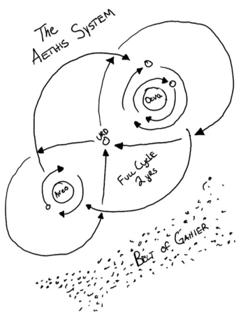
| Number | Name | |—|—| | 1 | turn of ritkus | | 2 | lythantos’ breath | | 3 | the shaded aveo | | 4 | the burning oeva | | 5 | the dying flower | | 6 | roahns becoming | | 7 | falling leaf | | 8 | winterblight | | 9 | changing tide | | 10 | mahro’s blessing | | 11 | ettphemones return |
Important Names of Present Day#
For important names in history used primarily as reference, refer to the previous section: The Greater Provinces.
Lythantos#
Avatar of Magic, one of the three prominent names worshiped throughout Sedia. Said to be brother of Dekkashraen and lover of Ettephemone. Said to have created the Ancients in his own image. Exuvae seeks to uncover all histories entangled with this deity. It’s sometimes argued that he was the most powerful of the three and his magic holds the entire universe from being thrown into complete disarray. He is still missing to this day.
Ettephemone#
Avatar of Life, lover of Lythantos, and creator of most all the races. She was hurt, sometimes it’s said she was killed, by Dekkashraen causing the War of Souls. Without her presence Lythantos has no will to keep Urd from its own destruction. When and if this avatar ever returns there will be peace unending. She is still missing.
Dekkashraen#
Avatar of Death, brother of Lythantos, and harbinger of war. He destroyed Ettephemone in jealousy of his brother’s love and devotion causing the War of Souls in his brother’s absence, eventually leaving himself in shame. He is still missing.
Qattja#
Dark Queen of Narsis controls Schzo’ersch and has her mischievous fingers hidden in politics throughout most of Sedia. All who have sat in her presence fear her and know her power is real. She’s said to support Xorcos’ war against Julius Mandak and The Legion.
Taz colespri#
Familiar of Donovan Xorcos. He’s said to have died twice already. A famous thief. Originally from Narsis.
Donovan Xorcos#
Dead son of Xorcos. Or rather, supposedly dead son of Xorcos.
barkeep telenadus#
Lives in Crecia and is often referred to as a Quest master. He has numerous social connections throughout Sedia. He owns the Shatteredkeep Inn
mykil ironfist#
Master Blacksmith in Tharsis, well known for his grand works. Also rumored to be the son of Mishnal Stonecleaver.
mishnal stonecleaver#
Former King of Tharsis. Some believe Quillilia Stonecleaver poisoned him to gain control of Tharsis. Others say that Quillilias husband has died and she’s covered up his death to remain in control of the kingdom without any form of disorder. Others still say that he’s sick and should come back to his office soon.
quillilia stonecleaver#
Queen of Tharsis, acting reagent of the kingdom of Tharsis, or province respectively. She’s the sister of Evelyn Elswin and gave her maiden name up to marry Mishnal Stonecleaver.
evelyn elswin#
Sister of Quillilia and Lord Elswin or Bredrick, has a small hand in politics and simultaneously the Maginaerum Arcanum’s spire politics as well. Because she’s a mage she has great influence over others carrying the weight of her office. Unfortunately she left the spire out of terms that caused a slight disorder, sending Lady Leeza to retrieve Evelyn. It’s said she’s still being pursued by the Emissary. She is a famous adventurer.
bredrick elswin#
Former Lord, Husband of Lela Davenport. He gave up his lordship to take care of his wife and study his art of war. He’s a famous adventurer classified as a monk whose actual rank is still unknown.
Lela davenport#
Legendary Hero and adventurer, partner with Julius Mandak in his war. There are many stories that carry her name across the continent.
julius mandak#
Legendary Hero and adventurer, leads The Legion across the continent to gain support in the war he’s raging against Xorcos and his supposed corruption of the natural order within Crecia, Tharsis, and other partnering cities. It’s often rumored of his large height and grand form in battle, it is important to note he doesn’t reach but 3’ 2” as a Halfling and rides into battle on a pony. His form of battle however was no lie.
gregory mandak#
Commander of The Legion under Julius Mandak. Took Julius’ last name as an indication of loyalty under his lordship. He stays with the legion which is mostly stationed in Tharsis, building force.
zacharie mandak#
Mandaks 1st Guard of The Legion. Took Julius’ last name as an indication of loyalty under his lordship. He mostly stays in Tharsis with his lord, Julius.
lord dreknolt#
Crecian Archlord, power player in the war against Xorcos with Mandaks Legion.
duke xorcos#
Leads armies against Mandak, he is mostly stationed in Narsis.
Rodan#
Blind Crecian Halfling said to have been of some importance in influencing Julius Mandaks decision to wage war upon Xorcos. People have since searched for the mysterious halfling named Rodan to avail.
Volo#
Legendary Assassin sent to kill Julius Mandak on numerous occasions. He is said to hail from New Saellem.
Lady Leeza#
Maginaerum Emissary sent to retrieve Evelyn Elswin and bring her back to the spire. The mage spire is in Tharsis.
Archmagi Dorso VI#
Head of the Emissary Counsel. The mage spire is in Tharsis.
Master Mattik#
Minister of political affairs at the Maginaerum Arcanum in Tharsis. He sometimes leaves the spire to recruit promising mages
Lyssa#
Famous Adventurer
Penn#
Famous Adventurer
Dente#
Famous Adventurer
Anowyn#
Famous Adventurer
Brandin#
Dead miner who hailed from Dupree who allegedly found a shard of the Everspark, Lythantos’ crystal staff that was destroyed and spread about the continent when he cast the portal to leave the world of Urd.
Grandin#
Grandins Brother who accompanied Grandin mining in the caves south of Dupree. He is missing as well as the shard.
Baron Penifus#
Powerplayer, strong in the Tharsinian politics regarding Mandaks war, controls Dupree.
Shipcaptain Lockard#
Doonan, he rides the ship Forager.
Shiphand Elayus#
Doonan, he rides the ship Forager.
Kevin#
Powerpolayer, strong in the Tharsinian politics regarding Mandaks war, controls Carthage.
Shipmaster Thomas#
Doonan, he controls the ships going in and out of Doonans ports, friend of Shipcaptain Lockard.
Shiphand Grilton#
Doonan, he rides the ship Forager
Manager Sherii#
Resides in Tharsis, mischievous bar owner who has ties to the clan Schzo’ersch.
Jonathan#
Gnomish priest who controls the temple of Goad South of Tharsis
Matt#
A famous questmaster who owns Matts Grill in Tharsis. It’s rumored he was once a famous thief.